 |
#1 CA-NV-OR
|
PIDs=MV0393, MV0392 (NGS Datasheet)
Maps: [Sat] Google, Bing [Topo] Acme, Gmap4 MyTopo [Peaks] ListOfJohn, Summitpost
Photos: Flickr, Loc.alize.us, Bing, Google
Weather: NWS Forecase, NOAA Snow Depth
Nearby POI: Opencaching.us, Waymarking.com
The Corner Corner: http://www.bjbsoftware.com/corners/pointdetail.php3?point=13
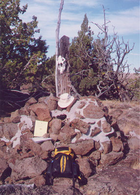
Wikipedia notes: Marked with a cairn.
Wiki article: File:California_Nevada_Oregon_Tripoint_Monument_Von_Schmidt_1872_NGS_MV0393_2.jpg
Newsletter index: #99-12q4-p20
Trip Report - July 4, 1991 - Jack Parsell
 ACCESS ROUTE: From Adel, OR, go S 17 miles to the CA border. Continue about l/2 mile S to a faint 4WD road heading E. With a high clearance vehicle you can drive in the first mile. Otherwise, leave car at the main road and hike to the end of the 4WD road, then continue down into Cow Head Slough and up the other side of the ravine.
Then, heading slightly N of E, cross flat, open terrain, passing a small dry lake bed on your right. At about 1 1/4 miles from the end of the 4WD road, you will reach the CA - NV fence line. Note, there is no fence on the OR - CA line. After reaching the CA - NV fence line, follow it N to the VonSchmidt marker, which is a large stone cairn dated 1872. This is on the Nevada side of the fence, with witness marker signs on several trees around the cairn. A survey to determine the NE comer of CA was made by D. G. Major in 1868. In 1872-73 W. A. VonSchmidt surveyed the CA- NV boundary and found Major's corner about 3 1/4 miles too far. W. VonSchmidt set the comer at the point he determined to be N 42°, W 120°. On the CA side of the fence, 117 ft. SW of the VonSchmidt post is a Geodetic Survey marker at N 41° 59.689', W 119° 59.927'.
Mark your route on the way in, or take a compass heading, or GPS bearing. Otherwise, it is difficult to find the 4WD road on your return. If approaching from the South, from Cedarville, CA, go North 43 miles to the above mentioned 4WD path.
Update - late Sept 2000 - Richard L Carey
You can view the trip report at Peakbagging