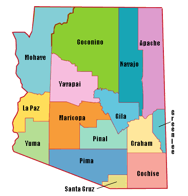

Hiking the 15 county highpoints (cohp) of Arizona is a great project for both residents of the state and those taking vacations there. This is born out by the fact that AZ has the most cohp state completers of any state.
With about 3142 counties to divide up between the states, we see that AZ is well under the average of 63 counties. In addition, none of the counties requires strapping on crampons, dangling off cliffs, or overnight backpacks. Weather is generally pleasant on the summits, and you are treated to expansive views on 12 of these locations.
Of course any outdoor adventure has dangers, and hikers need to take care in Arizona to avoid poisonous animals, sharp plants, dehydration in summer, and snowstorms in winter.
You will enjoy trails to the summits of Humphreys Peak (state HP), Mount Baldy, Chiricahua Peak and Mount Wrightson. These all gain 2,000 feet or more, and will take most of a day for the average hiker. Although forests are seen along all of these trails, only Chiricahua has trees at the summit that block views. All of these peaks rise over 9,000 feet, and will be snow covered for most/all of the winter. Take care to avoid thunderstorms on these peaks.
Even easier are drives close to the tops of Greenlee cohp, Mount Lemmon, Mount Union, and Harquahala Mountain. You will want a 4wd to reach the top of Harquahala, though high clearance can get to within a mile of the summit. Greenlee will require careful navigation, and the remaining two may require mile long hikes depending on gate closures.
Expect challenging off trail segments and map navigating on Hualapai Peak, Navajo cohp, Browns Peak and Signal Peak. Don't mess with Signal in the summer - it is just too hot for any sane human.
Add in a couple liners to the roster with Gila and Pinal cohps. You can drive near the Gila high points, but Pinal requires a tough hike - or a tougher 4wd drive.
The final peak, Mount Graham, has restricted access due to the Red Squirrel refuge.
For additional information see the trip reports and maps for all 15
high points at www.cohp.org