 | ||
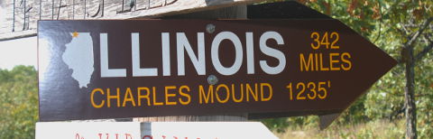
 | Elevation: | 1,235ft / 376m |
| Difficulty: | Martin=2, YDS=1, COHP=0 | |
| Gain & R/T-Dist: | 275ft & 3mi | |
| Prominence: | 95ft / 29m | |
| Isolation: | 3mi / 4km | |
| Dominance: | 7.69 altitude class 0H | |
| Steepness ∠: | 6.978° @100m, 3.374° @800m | |
| Lat/Lon (WGS84): | 42°30'15.09" N, 90°14'24.00" W | |
| 42.504193, -90.240001 | ||
| 15T 726771 4709450 | ||
| Lat/Lon (NAD27): | 42°30'15.07" N, 90°14'23.63" W | |
| 42.504185, -90.239896 | ||
| 15T 726786 4709236 | ||
| Twsp Rng Sect: | Fourth T29N R2E S13 | |
| What3Words: | enforcement.achievement.ensemble | |
| MapCode: | US-IL 0Q0.7FS-M | |
| Maidenhead: | EN42vm11ea | |
| PlusCode: | 86JFGQ35+MXHQ | |
| Geohash | geo32:9zxcf99hzef7, geo36:9KHXRQXgtB | |
USGS Quadrangle: Shullsburg (WI) (large ZIP/PDF)
Time Zone:
Maps:
360° Views:
Visible Summits: PeakFinder, HeyWhatsThat
Panorama:

GSphere:

Photos:
Webcams:
[Maps] NOAA, Webcams.Travel
Weather:
NWS Forecast, Mtn-Forecast, NOAA Snow Depth
Severe Weather: national and local
Historical Weather: WeatherSpark, weather.com
Severe Weather: national and local
Historical Weather: WeatherSpark, weather.com
10-day:
[Scales Mound] Wunderground, Accuweather+UV
Warning:
Storms:
Flooding:
UV Index:
Fire:
Winter:
Planets:
CalSKY:
Satellites:
Airplanes:
Cell Phone:
CellMapper: AT+T, Sprint, T-Mobile, Verizon
Vendor: AT+T, Sprint, T-Mobile, Verizon
OpenSignal, WhistleOut
Vendor: AT+T, Sprint, T-Mobile, Verizon
OpenSignal, WhistleOut
HAM Radio:
ITU: Rgn=02 Zone=07, CQ-Zone=04, CallSign=W9, GridSquare EN42vm
On The Air:
Repeaters:
RepeaterBook (table), LevineCentral (map)
More Info:
Wikipedia:
Facebook:
Twitter:
Instagram:
| Geology | Class Type of Material | Type Earth Material | Age | Landform Physiographic Province |
|---|---|---|---|---|
| Highpoint Geology | Sedimentary | Dolomite | Silurian | Hill |
| CEPS UNH | Sedimentary | Dolostone | Silurian | Interior Lowlands |
Nearby Stuff:
Airports:
Atlas Obscura:
Deg Confluence:
Geocaching:
Historic Sites:
Megaliths:
204mi/328km - Timms Hill, WI
284mi/457km - Hawkeye Point, IA
Nearby Lowpoints:
159mi/256km - Mississippi River, IA
224mi/360km - Lake Michigan, WI
Nearby Tripoints:
21mi/33km - #59 IL-IA-WI
85mi/136km - #58 IA-MN-WI
159mi/256km - #60 IL-IA-MO
163mi/263km - #68 IL-IN-MI
164mi/264km - #67 IL-MI-WI
284mi/457km - #22 IN-MI-OH
Newsletter articles:
• #62-3q03-p21-22 [Roger Rowlett] Interview with Jean and Wayne Sterler - Owners of Charles Mound
• #82-3q08-p10-11 [John Mitchler] Paradise Lost but Friends Gained
• #82-3q08-p11 [John Mitchler] History of Charles Mound
• #94-3q11-p29 [Steve Gruhn] First Recorded Ascents of State Highpoints
• #99-4q12-p8 [Jerry Brekhus] Highest Hills
• #99-4q12-p8 [James Suits] 360deg Panoramic Highpoint Photography
• #105-2q14-p13 [Connie Ricca] State highpoint photos - local.msn.com/outdoors/highest-points-in-each-state
• #109-2q15-p24-27 [Rick Hartman] Benchmarks
• #117-2q17-p27-31 [Lanny Wexler] The Origin of State Highpoint Names
Newsletter updates:
• #104-1q14-p10 [John Mitchler] Open access dates
• #105-2q14-p12 [John Mitchler] Open access dates
• #106-3q14-p12 [John Mitchler] Open access dates
• #107-4q14-p13 [John Mitchler] Open access dates
• #108-1q15-p10 [John Mitchler] Open access dates
• #109-2q15-p10 [John Mitchler] Open access dates
• #110-3q15-p11 [John Mitchler] Open access dates
• #111-4q15-p12 [John Mitchler] Open access dates
• #112-1q16-p7 [John Mitchler] Open access dates
• #112-1q16-p7 [John Mitchler] Feedback on winter ascents - photos
• #113-2q16-p15 [John Mitchler] Open access dates
• #114-3q16-p22 [John Mitchler] Open access dates
• #114-3q16-p22 [John Mitchler] http://www.iamlubos.com/highpoints/
• #115-4q16-p22 [John Mitchler] Open access dates
• #117-2q17-p19 [John Mitchler] Open access dates
• #118-3q17-p27 [Cindy Harrison] Please park on one side of road only
• #119-4q17-p21 [John Mitchler] Open access dates