 | ||
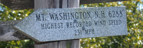
 | Elevation: | 6,288ft / 1,917m |
| Difficulty: | Martin=1, YDS=1, COHP=0 | |
| Gain & R/T-Dist: | 20ft & < 0.1mi | |
| Prominence: | 6,148ft / 1,874m Ridge 2,290mi / 3,685km | |
| Isolation: | 819mi / 1,318km | |
| Dominance: | 97.77 altitude class 2H | |
| Steepness ∠: | 10.336° @100m, 17.838° @800m | |
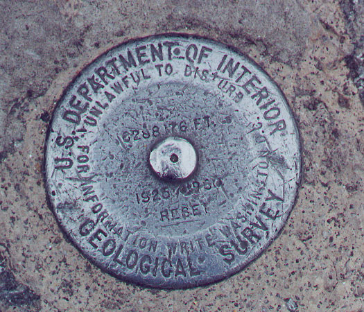
| Lat/Lon (WGS84): | 44°16'14.33" N, 71°18'10.93" W | |
| 44.270647, -71.303036 | ||
| 19T 316196 4904513 | ||
| Lat/Lon (NAD27): | 44°16'14.47" N, 71°18'12.90" W | |
| 44.270685, -71.303583 | ||
| 19T 316147 4904302 | ||
| What3Words: | stealth.swinging.steep | |
| MapCode: | US-NH QN4.929-Y | |
| Maidenhead: | FN44ig34pw | |
| PlusCode: | 87PC7MCW+7Q4X | |
| Geohash | geo32:drv7c7nxnydz, geo36:9L7t9M2CqF | |
USGS Quadrangle: Mount Washington (large ZIP/PDF)
Time Zone:
Maps:
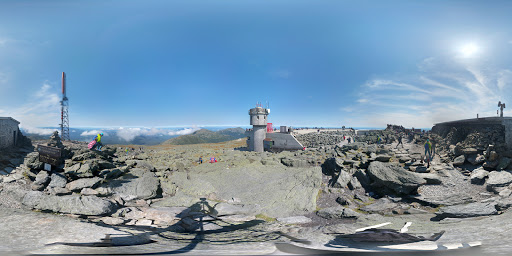
360° Views:
Visible Summits: PeakFinder, HeyWhatsThat
Panorama:

GSphere:
Photos:
Webcams:
Weather:
NWS Forecast, Mtn-Forecast, NOAA Snow Depth
Severe Weather: national and local
Historical Weather: WeatherSpark, weather.com
Severe Weather: national and local
Historical Weather: WeatherSpark, weather.com
10-day:
[Gorham] Wunderground, Accuweather+UV
Warning:
Storms:
Flooding:
UV Index:
Fire:
Planets:
CalSKY:
Satellites:
Airplanes:
Cell Phone:
CellMapper: AT+T, Sprint, T-Mobile, Verizon
Vendor: AT+T, Sprint, T-Mobile, Verizon
OpenSignal, WhistleOut
Vendor: AT+T, Sprint, T-Mobile, Verizon
OpenSignal, WhistleOut
HAM Radio:
ITU: Rgn=02 Zone=08, CQ-Zone=05, CallSign=W1, GridSquare FN44ig
On The Air:
Repeaters:
RepeaterBook (table), LevineCentral (map)
More Info:
Wikipedia:
Facebook:
Instagram:
| Geology | Class Type of Material | Type Earth Material | Age | Landform Physiographic Province |
|---|---|---|---|---|
| Highpoint Geology | Metamorphic | Schist | Devonian | Massif |
| CEPS UNH | Metamorphic | Schist | Devonian | Northern Appalachians |
Nearby Stuff:
Airports:
Atlas Obscura:
Deg Confluence:
Geocaching:
Historic Sites:
Megaliths:
77mi/124km - Mount Mansfield, VT
130mi/210km - Mount Marcy, NY
147mi/236km - Mount Greylock, MA
162mi/261km - Mount Katahdin (Baxter Peak), ME
169mi/272km - Jerimoth Hill, RI
189mi/304km - Mount Frissell-South Slope, CT
265mi/427km - High Point, NJ
Nearby Lowpoints:
89mi/143km - Atlantic Ocean, NH
95mi/153km - Lake Champlain, VT
132mi/212km - Atlantic Ocean, MA
176mi/284km - Atlantic Ocean, ME
196mi/315km - Atlantic Ocean, RI
221mi/356km - Long Island Sound, CT
281mi/453km - Atlantic Ocean, NY
296mi/477km - Atlantic Ocean, NJ
Nearby Tripoints:
52mi/84km - #116 NH-QC-VT
72mi/116km - #117 ME-NH-QC
112mi/181km - #115 NY-QC-VT
121mi/195km - #37 MA-NH-VT
144mi/232km - #36 MA-NY-VT
158mi/255km - #38 CT-MA-RI
173mi/278km - #114 NY-ON-QC
189mi/304km - #35 CT-MA-NY
207mi/333km - #74 CT-NY-RI
235mi/379km - #118 ME-NB-QC
265mi/426km - #34 NJ-NY-PA
Newsletter articles:
• #69-2q05-p24 [Newsletter] Some Information about New Hampshire Highpionts
• #69-2q05-p33 [Pete Thompson] Geology of Mount Washington
• #94-3q11-p29 [Steve Gruhn] First Recorded Ascents of State Highpoints
• #99-4q12-p8 [Jerry Brekhus] Highest Hills
• #99-4q12-p8 [James Suits] 360deg Panoramic Highpoint Photography
• #105-2q14-p13 [Connie Ricca] State highpoint photos - local.msn.com/outdoors/highest-points-in-each-state
• #109-2q15-p24-27 [Rick Hartman] Benchmarks
• #117-2q17-p27-31 [Lanny Wexler] The Origin of State Highpoint Names
Newsletter updates:
• #110-3q15-p12 [Woody Connette] World's Most Thrilling Trails
• #110-3q15-p12 [John Mitchler] Camel makes summit
• #114-3q16-p22 [John Mitchler] http://www.iamlubos.com/highpoints/