 | Timms Hill, WI Highpoint of Price County, WI |
|
 | Elevation: | 1,951ft / 595m |
| Difficulty: | Martin=1, YDS=1, COHP=1 | |
| Gain & R/T-Dist: | 120ft & 0mi | |
| Prominence: | 425ft / 130m | |
| Isolation: | 92mi / 148km | |
| Dominance: | 21.78 altitude class 0H | |
| Steepness ∠: | 10.380° @100m, 2.617° @800m | |
| Lat/Lon (WGS84): | 45°27'2.74" N, 90°11'43.42" W | |
| 45.450762, -90.195394 | ||
| 15T 719305 5036853 | ||
| Lat/Lon (NAD27): | 45°27'2.76" N, 90°11'43.03" W | |
| 45.450766, -90.195285 | ||
| 15T 719320 5036636 | ||
| Twsp Rng Sect: | Fourth T34N R2E S11 | |
| What3Words: | improbably.ketchup.dearest | |
| MapCode: | US-WI QMY3.B9-9 | |
| Maidenhead: | EN45vk68ne | |
| PlusCode: | 86QFFR23+8R5F | |
| Geohash | geo32:cbpfed19yups, geo36:9gXHNL6RT3 | |
USGS Quadrangle: Timms Hill (large ZIP/PDF)
Time Zone:
Maps:
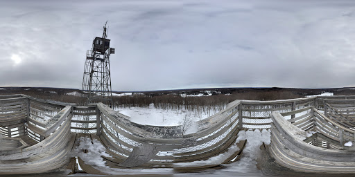
360° Views:
Visible Summits: PeakFinder, HeyWhatsThat
GSphere:
Photos:
Webcams:
Weather:
NWS Forecast, Mtn-Forecast, NOAA Snow Depth
Severe Weather: national and local
Historical Weather: WeatherSpark, weather.com
Severe Weather: national and local
Historical Weather: WeatherSpark, weather.com
10-day:
[Ogema] Wunderground, Accuweather+UV
Warning:
Storms:
Flooding:
UV Index:
Fire:
Winter:
Aurora:
Planets:
CalSKY:
Satellites:
Airplanes:
Cell Phone:
CellMapper: AT+T, Sprint, T-Mobile, Verizon
Vendor: AT+T, Sprint, T-Mobile, Verizon
OpenSignal, WhistleOut
Vendor: AT+T, Sprint, T-Mobile, Verizon
OpenSignal, WhistleOut
HAM Radio:
ITU: Rgn=02 Zone=07, CQ-Zone=04, CallSign=W9, GridSquare EN45vk
On The Air:
Repeaters:
RepeaterBook (table), LevineCentral (map)
More Info:
Wikipedia:
Facebook:
Twitter:
Instagram:
| Geology | Class Type of Material | Type Earth Material | Age | Landform Physiographic Province |
|---|---|---|---|---|
| Highpoint Geology | Unconsolidated | Glacial till | Quaternary | Moraine hill |
| CEPS UNH | Unconsolidated | Glacial till | Quaternary | Canadian Shield |
Nearby Stuff:
Airports:
Atlas Obscura:
Deg Confluence:
Geocaching:
Historic Sites:
Megaliths:
133mi/214km - Mount Arvon, MI
170mi/273km - Eagle Mountain, MN
204mi/328km - Charles Mound, IL
304mi/490km - Hawkeye Point, IA
Nearby Lowpoints:
127mi/205km - Lake Michigan, WI
158mi/254km - Lake Superior, MN
Nearby Tripoints:
127mi/205km - #57 MI-MN-WI
144mi/232km - #58 IA-MN-WI
180mi/290km - #110 MI-MN-ON
204mi/329km - #59 IL-IA-WI
258mi/416km - #67 IL-MI-WI
296mi/476km - #68 IL-IN-MI
309mi/497km - #17 MN-ND-SD
Newsletter articles:
• #77-2q07-p24-25 [Jim Mick] Timms Hill - Apostrophe or Not?
• #94-3q11-p29 [Steve Gruhn] First Recorded Ascents of State Highpoints
• #99-4q12-p8 [Jerry Brekhus] Highest Hills
• #99-4q12-p8 [James Suits] 360deg Panoramic Highpoint Photography
• #105-2q14-p13 [Connie Ricca] State highpoint photos - local.msn.com/outdoors/highest-points-in-each-state
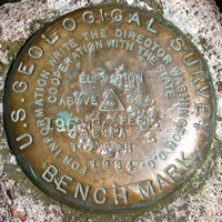
• #109-2q15-p24-27 [Rick Hartman] Benchmarks
• #117-2q17-p27-31 [Lanny Wexler] The Origin of State Highpoint Names
Newsletter updates:
• #114-3q16-p22 [John Mitchler] http://www.iamlubos.com/highpoints/
• #117-2q17-p18 [Doug Urban] Logging and vandalism - photos