 |
|
Maps: [Sat] Google, Bing [Topo] Acme, Gmap4 MyTopo [Peaks] ListOfJohn, Summitpost
Photos: Flickr, Loc.alize.us, Bing, Google
Videos: Vimeo, Youtube
Weather: NWS Forecase, NOAA Snow Depth
Nearby POI: Opencaching.us, Waymarking.com
Nearby Highpoints:
17mi/27km - Mount Davis, PA
40mi/64km - Backbone Mountain (Hoye Crest), MD
71mi/114km - Spruce Knob, WV
139mi/223km - Point Reno, DC
210mi/338km - Ebright Azimuth, DE
229mi/368km - Campbell Hill, OH
239mi/385km - Mount Rogers, VA
268mi/432km - Black Mountain, KY
276mi/444km - High Point, NJ
286mi/460km - Hoosier High Point, IN
Nearby Lowpoints:
98mi/157km - Potomac River, WV
146mi/235km - Potomac River (MD), DC
216mi/347km - Delaware River, PA
243mi/391km - Atlantic Ocean, DE
254mi/409km - Atlantic Ocean, MD
255mi/410km - Lake Erie, MI
271mi/436km - Atlantic Ocean, VA
288mi/464km - Ohio River, OH
293mi/472km - Atlantic Ocean, NJ
Nearby Tripoints:
84mi/135km - #72 OH-PA-WV
98mi/157km - #31 MD-VA-WV
137mi/221km - #32.1 DC-MD-VA (North)
145mi/234km - #32.2 DC-MD-VA (South)
188mi/302km - #112 OH-ON-PA
190mi/305km - #71 KY-OH-WV
194mi/312km - #113 NY-ON-PA
196mi/315km - #33 DE-MD-PA
202mi/325km - #29 KY-VA-WV
216mi/347km - #73 DE-NJ-PA
245mi/394km - #111 MI-OH-ON
247mi/398km - #28 NC-TN-VA
275mi/443km - #34 NJ-NY-PA
288mi/464km - #70 IN-KY-OH
311mi/500km - #22 IN-MI-OH
The Corner Corner: http://www.bjbsoftware.com/corners/pointdetail.php3?point=55
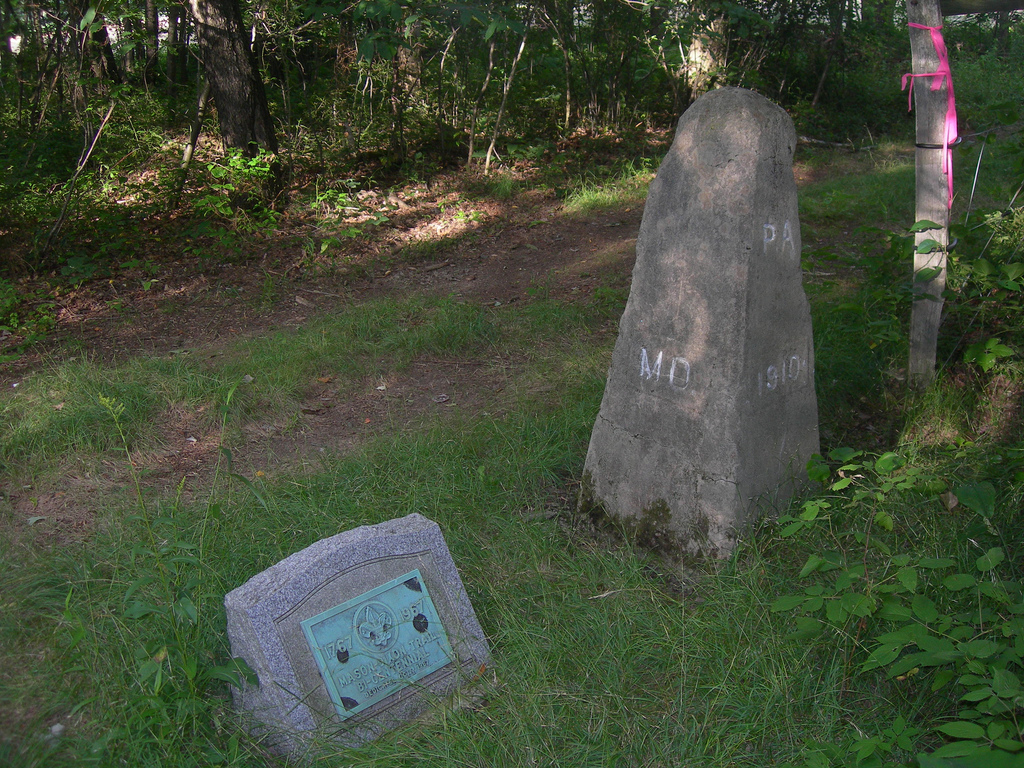
Wikipedia notes: Marked with a pyramid-like stone.
HPC Forum: #30 MD-PA-WV
Trip Report - May 21, 1991 - Jack Parsell
 ACCESS ROUTE: From Markleysburg, PA, where Route 281 makes a right angle tum, go S on Brown Hill Road, (not on route 42). Disregard the "No Outlet" sign. Brown Hill Road angles off to the SW, then goes W and finally S just before crossing into MD at about 1 1/2 miles from the comer of Route 281. The last 1/2 mile is a very rough gravel section. At the MD-PA boundary, which is the Mason and Dixon Line, hike due W 0.2 mile along a pipeline maintenance road which parallels the MD-PA line. Where this road passes under a high-voltage power line, look to the 10 o'clock position about 100 ft. to a small clearing, where the 1910 Tri-State monument is located. In addition to the Tri-State monument there is another monument put there by the Boy Scouts in 1967, commemorating the bicentennial of the establishment of the Mason and Dixon line.
The Mason and Dixon line survey started in 1763 and reached the NW comer of MD in 1767. This was not on a particular latitude, but was based on complicated measurements which determined the arc at the N end of Delaware.
Update - ??? - Richard L Carey
You can view the trip report at Peakbagging
Update - Oct 21, 2005 - Bill Wentzel
Update - Dec 30, 2007 - Bill Wentzel
Bill Wentzel has visited this tri-point twice and provides updated road conditions and additional photos. You can read his 2005 and 2007 trip reports for more details. [Ed: Because the blog images obscure some of the text, it is quoted here. See the blog post for additional links.] Bill has a Flickr photo album as well.
A short drive from Mt. Davis, Markleysburg is aprx. 25 miles SW of the PA hp. In Markleysburg, locate the junction of Rt 281 where it makes a sharp right angle turn. At this corner, Brown Hill Rd. intersects. Disregard the "No Outlet" sign and follow this route for 1.4 miles, which breaks down to a ragged paved road for .4 miles, a better finely graveled section for .3 miles, then a rough, stoney but doable stretch for .7 miles. [Ed from 2007: We did this in a front-wheel drive van going slowly and carefully. Some mud and puddles were encountered at the parking site.] At the first yellow gas pipeline markers, park on the left; the tri-point is located to the right via the pipeline service road.Head west toward the power line which can be seen in the distance. Here, the pipeline approach is a tad north of the Mason-Dixon Line on the PA side and provides an easy .2 mile walk to the marker. While crossing under the power lines, look up. When just below the final strand, make a hard left and go aprx. 35ft. off-road to the PA/WV/MD 3Pt. Magellan 315 reading: 39/43/16N, 79/28/36W.
Per Jack Parsell's description, "...there is another monument put there by the Boy Scouts in 1967 commemorating the bicentennial of the establishment of the Mason-Dixon Line." Note that just beyond the parking pull-off, where a second pipeline crosses the road, an historical M-D Line marker is located there, dated 188? along with other time-worn hieroglyphic-like engravings.