 |
|
Maps: [Sat] Google, Bing [Topo] Acme, Gmap4 MyTopo [Peaks] ListOfJohn, Summitpost
Photos: Flickr, Loc.alize.us, Bing, Google
Videos: Vimeo, Youtube
Weather: NWS Forecase, NOAA Snow Depth
Nearby POI: Opencaching.us, Waymarking.com
Nearby Highpoints:
250mi/402km - Guadalupe Peak, TX
Nearby Lowpoints:
301mi/485km - Red Bluff Reservoir, NM
Nearby Tripoints:
17mi/28km - #154 CHH-NM-SON
152mi/244km - #155 CHH-NM-TX
HPC Forum: #153 AZ-NM-SON
Trip Report - Jan 15, 2018 - Andy Martin, Mick Dunn
You can view Mick Dunn's photo album on Facebook [FB account required]
ACCESS USA side: This point is located at/near Monument 71 on the Mexican border (31.3318, -109.0499). The USA land is BLM at the Monument, but Mark Nichols told me about a locked gate on private land located at 31.3347, -109.0876. This adds a couple miles each way to the hike. We parked well off the road a bit north of the gate and walked through the pedestrian opening on the east end, as described in this 2013 hikers write up and in this 2007 birders write up.
The two weather beaten wooden signs on the gate read
GUADALUPE RANCHCLOSED TO HUNTING, TRAPPING AND OFF ROAD VEHICLES
There are some impressive vehicle barriers connected to the massive gate. I [Andy Martin] believe they were built by Border Patrol to stop vehicles driving over the border at nearby Puerta Blanca and getting on to the Guadalupe Canyon Road westbound. Eastbound is a dead end.
We saw no signs proclaiming No Trespassing here or anywhere else on the hike. We did not see anyone or any vehicles while hiking, and did not see much sign of Border Patrol activity past the gate. Did not spot any illegals trash along the main road, but once we started cross country there were the usual food & water containers, plus clothes and shoes. This trash was not very abundant or recent.
On returning from the hike my '04 Accord was all in one piece. On the drive back to Douglas I pulled over to let a Border Patrol vehicle pass and he stopped for a brief and friendly chat.
If Border Patrol sees you in this area they will likely want to know what you are doing. It is best to stop and let them know.
ACCESS Mexico side: (we did not try this). It should be possible to cross at Douglas and park here on the north side of highway 2 (31.3257, -109.0515). This gives a shorter and quicker hike.
There are some issues here:
- Everyone will need passport.
- You will need vehicle registration (and maybe title ??)
- Vehicle will be left 1 hour or more near a busy highway.
- Likely have to pay $20 per person for visas.
- Likely have to pay about $20 for car papers.
- You should get 1 day Mexican Auto insurance coverage.
- Possible delays crossing the border twice.
- Possible interactions with smugglers on their home turf.
Route: 7 miles RT and 700' gain to tri-point only (we added some extra on the return)
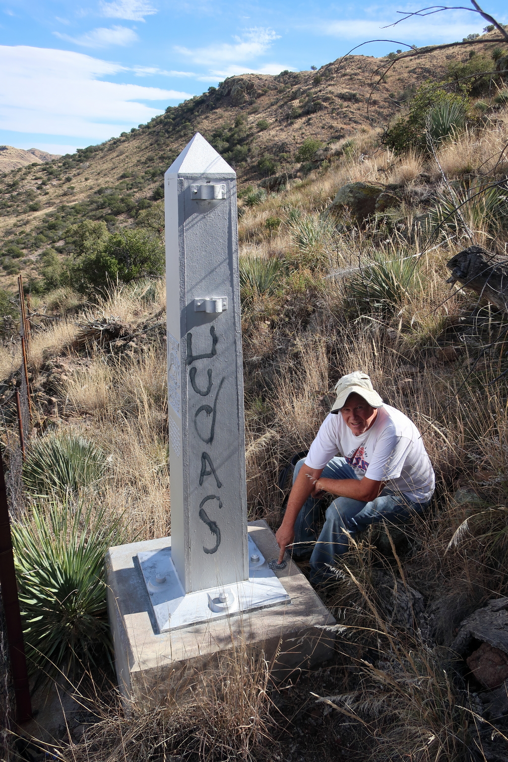
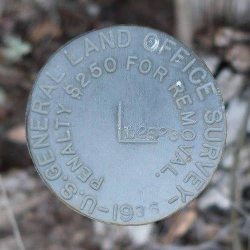
We walked the wide dirt road from the gate to 31.3437, -109.0580. Then followed a minor jeep road to 31.3417, -109.0521. Then followed a dry wash south to the fence at New Mexico line. Crossed fence and followed wash until it curled back to AZ. Then followed fence due south to Monument 71. (first pic - Mick at the Monument). An International Boundary Marker is visible in the first pic. A close up view is in the second pic. Mick found an old register jar in a cairn just east of the Monument, with a couple entries from the last millennium. (no one I [Andy Martin] recognized)
 Before reaching Monument 71 we found the mapped monument 4652T on the state line about 1/4 mile to the north. And about 50 feet north of the Monument 71 we found an odd small brass "corner monument" (Mick got a pic) where the Arizona & Mexico fence headed west. The New Mexico & Mexico fence heads east from Monument 71. Thus the border fence makes a noticeable jog here.
Cross country travel was an average bushwack - some brush, cactus and rocks to dodge, with faint game trails in places. A gully is crossed just north of the Monument. We saw no signs of recent cattle grazing. This ranch used to be the home of Drum Hadley, who likely limited/eliminated grazing here:
After resting at the monument a bit we hiked to the Guadalupe Mountains range HP x 5176T. (no register found) From here my sight level showed x 5171T to be about 3 feet higher so we hiked over there, left a small register, and then walked back to the car.
Information on the jog - where is the tri-point?
![The National Map showing the border area in question [Andy Martin Jan 2018]](https://highpointers.org/wp-content/uploads/tripoints/images/imgAZ-NM-SON-national-map.jpg) |
![The latest topo map showing the border area in question [Andy Martin Jan 2018]](https://highpointers.org/wp-content/uploads/tripoints/images/imgAZ-NM-SON-topo-latestcr.jpg) |
The jog is clearly shown on the National Map (screenshot on left). The fence lines follow the state boundaries shown in yellow. And another boundary line is shown just south of the Arizona & Mexico fence line. If we assume the international border follows the yellow line then the tri point is at the "corner monument", not at Monument 71. If we assume the international border runs straight through Monument 71 and does not jog then Monument 71 is at the tri point.
The 2014 Guadalupe Canyon AZ-NM-SON map (screenshot on right) further confuses the issue by showing the international border following neither fenceline.
I [Andy Martin] searched the internet looking for survey datasheets on the various markers (not found) and some explanation of the jog, but struck out.
Thus the Tri Point Tri Bunal will have to resolve this, and visitors are advised to touch every likely point ;)
Historical Information:
![Description of the Monument and surround area [Report of the Boundary Commission ... 1898]](https://highpointers.org/wp-content/uploads/tripoints/images/imgAZ-NM-SON-page187.jpg) |
![Benchmark at Monument 71 [Andy Martin, Jan, 2018]](https://highpointers.org/wp-content/uploads/tripoints/images/imgAZ-NM-SON-mon71old.jpg) |
[Ed: Andy sent me these two links. You can view the book at https://hdl.handle.net/2027/loc.ark:/13960/t10p1pr7v and a photo album of the border monuments at https://digital.library.unt.edu/ark:/67531/metadc1030/m1/].