 |
|
PIDs=HJ0488, HJ0392 (NGS Datasheet)
Maps: [Sat] Google, Bing [Topo] Acme, Gmap4 MyTopo [Peaks] ListOfJohn, Summitpost
Photos: Flickr, Loc.alize.us, Bing, Google
Videos: Vimeo, Youtube
Weather: NWS Forecase, NOAA Snow Depth
Nearby POI: Opencaching.us, Waymarking.com
Nearby Highpoints:
5mi/8km - Black Mesa, OK
137mi/221km - Wheeler Peak, NM
149mi/240km - Mount Sunflower, KS
237mi/382km - Mount Elbert, CO
282mi/454km - Panorama Point, NE
Nearby Lowpoints:
212mi/341km - Arikaree River, CO
Nearby Tripoints:
35mi/56km - #15 NM-OK-TX
53mi/85km - #16 CO-KS-OK
214mi/344km - #13 CO-KS-NE
282mi/454km - #12 CO-NE-WY
The Corner Corner: http://www.bjbsoftware.com/corners/pointdetail.php3?point=17
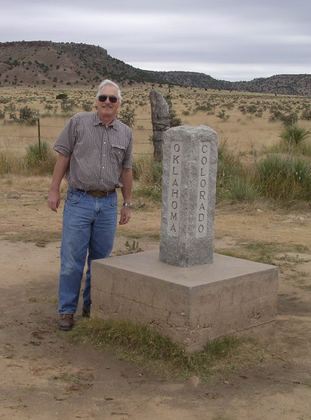
Wikipedia notes: Preston Monument.
Wiki article: Preston_Monument
HPC Forum: #14 CO-NM-OK
There was a Supreme Court case to settle a border dispute between Colorado and New Mexico. You can view it at "New Mexico v. Colorado, 267 U.S. 30 (1925)".
History of Tripoint and Trip Report - Fall, 1993 - Dale Sanderson
Dale Sanderson provides history on locating the tripoint at US Ends along with his trip report.
Trip Report - Oct 28, 1995 - Jack Parsell
 ACCESS ROUTE: From the Kenton, OK post office, go E on County Road 325 for 0.6 mile. Turn Left (N) on a county road, crossing the Cimarron River, and then following a tributary stream to the CO line, about 8.7 miles from route 325. At the Baca County, Colorado line turn L and proceed about 1 mile on a good dirt road which follows close to the OK- CO line and leads to the tri-State marker. A much older survey post is about 200 yards N over a knoll from the new marker. As with many of the tri-points, this one has been resurveyed and relocated several times. The present marker was installed in 1928 and confirmed in 1968, but recent satellite mapping shows it to be off by 4 feet.
The route to this tri-point from Kenton, OK, passes the Nature Conservancy parking lot, which is the access point for climbing to the Oklahoma high point, 4973 feet elevation on top of Black Mesa.
Trip Report - Oct 14, 2007 - Roger Simpson
You can view the trip report at "Simpson Family OK trip".
Update - Oct, 2015 - Frank Sutman
Just N of Kenton you will pass the High Point Bed & Breakfast. Further N on the road, there is trailhead parking and a trail that leads to fossilized dinosaur tracks.