 |
|
PIDs=AC5593, AC5592 (NGS Datasheet)
Maps: [Sat] Google, Bing [Topo] Acme, Gmap4 MyTopo [Peaks] ListOfJohn, Summitpost
Photos: Flickr, Loc.alize.us, Bing, Google
Videos: Vimeo, Youtube
Weather: NWS Forecase, NOAA Snow Depth
Nearby POI: Opencaching.us, Waymarking.com
Nearby Highpoints:
19mi/31km - Sassafras Mountain, SC
41mi/66km - Brasstown Bald, GA
45mi/72km - Clingmans Dome, TN
71mi/114km - Mount Mitchell, NC
133mi/214km - Black Mountain, KY
144mi/232km - Mount Rogers, VA
186mi/300km - Cheaha Mountain, AL
291mi/469km - Woodall Mountain, MS
Nearby Lowpoints:
239mi/385km - Atlantic Ocean, GA
242mi/389km - Atlantic Ocean, SC
272mi/438km - Atlantic Ocean, NC
299mi/481km - Ohio River, OH
Nearby Tripoints:
69mi/111km - #25 GA-NC-TN
115mi/185km - #27 KY-TN-VA
136mi/219km - #28 NC-TN-VA
141mi/227km - #23 AL-GA-TN
186mi/300km - #29 KY-VA-WV
238mi/383km - #71 KY-OH-WV
288mi/464km - #66 AL-MS-TN
298mi/479km - #24 AL-FL-GA
299mi/481km - #70 IN-KY-OH
The Corner Corner: http://www.bjbsoftware.com/corners/pointdetail.php3?point=26
Wikipedia notes: Located in Chattooga River very near marker on land.
Wiki article: Ellicott%27s_Rock
HPC Forum: #26 GA-NC-SC
Newsletter index:
• #100-13q1 p38 [Bill Wentzel] GA-NC-SC notes and tidbits with photo
 |
 |
ACCESS ROUTE: From Sylva, NC go S on Route 107 about 27 miles to Cashiers. From there continue on Route 107 almost 7 miles to a R (west) turn on Bull Pen Road which has two trailheads for Ellicott Rock. On the E side of the Chattooga River is the Bad Creek trail, starting at about 2.6 miles in on Bull Pen Road. Farther west, about 1.0 mile beyond the bridge over the Chattooga is the other trail head. Both trails are about 7 miles round trip to the tri-point on the Chattooga. The point where the trails cross the river is about 0.1 mile N of the tri-point rocks. The trails are easy walking, but become steep as they descend into the Chattooga gorge. Since the stones are near the E side of the river, access is easier from that side, especially in the winter when the river is too cold and swift for wading. Bull Pen Road can also be accessed from the west from Highlands, NC.
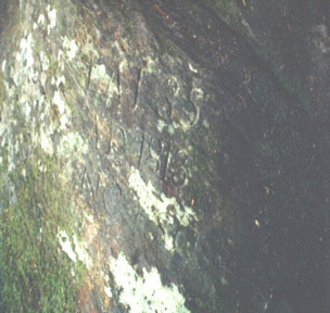
At first, we thought this tri-point was in the Chattooga River with no marker, but the USGS topo map shows "Ellicott Rock" at this location. Research disclosed that Ellicott Rock was considered by some to be the tri-point. Ten feet upstream from Ellicott Rock is Commissioner Rock and a little farther upstream is Chattooga Rock which has a bronze marker disc on top. Ellicott Rock bears the inscription: "Lat 35 AD 1813 NC + SC". Another 0.1 mile downstream from the Rocks in the middle of the river is another large boulder with tripoint markings scratched on the top. It is suspected that this is graffiti. No one of these four rocks is at the exact tripoint, but Ellicott and Commissioner come closest.
Update - May 23, 2000 - Richard L Carey
You can view the trip report at Peakbagging
Update - Oct 26, 2007 - Bill Wentzel
.") You can view the trip report at The Trek Stop. [Ed: Because the blog images obscure some of the text, it is quoted here. See the blog post for additional links.]
You can view the trip report at The Trek Stop. [Ed: Because the blog images obscure some of the text, it is quoted here. See the blog post for additional links.]
This one was a hoot and some sense of history came into play, considering what surveyors of old had to endure reaching/designating state lines and where they met. High-tech garb, computer-designed footwear, and the GPS weren't invented yet, nor were Mountain House, just add water, packaged meals.Looking at available maps describing several trails leading to the spot, we decided to approach from the south, following the river north, or upstream, on the Ellicott Rock Wilderness Chattooga Trail. As we went, the eerie notes of "Dueling Banjos" twanged in our ears, recalling this river's role in the movie Deliverance. Pre-trip research convinced us that this trail would be the shortest and least demanding of the lot. Indeed, it clocked at about 3.2 miles one way, undulated moderately, and led us over a combo of rocks, roots, and flat, easy trekking, too.
To access the Chattooga Trail from the east, go south into SC on Rt107 from Cashiers (Rt64) for 13mi to FS708 on the right. Follow this stony, dirt road 2.6mi to just short of the river bridge at Burrell's Ford parking area. From the west, head 12mi south from Highlands into GA via Rt28 to dirt road FS646 on left, then 7mi to trailhead and parking near the [Burrells Ford] bridge.
On reaching the hiking trail's "short wooden bridge," you're .1 mi downstream from the 3Pt. Some thoughtful faction placed a helpful yellow sign on the trail w/arrow; otherwise, w/o it a GPS might be useful since this rock is about 15ft below the trail and not easily identifiable, the engravings unobservable.
You'll need to climb down to river level to spy the markings and, even then, look closely, this isn't like mall shopping. Plan to soil your hi-tech, hike-wear and get some SC dirt under your fingernails as you make the descent (and ascent) glomming onto slippery rocks and roots, perhaps a branch by chance. In fact, 25ft of rope might prove handy (maybe just leave it behind?).
Note: At the time of this visit, the SE U.S. was experiencing a formidable drought and the Chattooga was lower and tamer than usual. Under "normal" river behavior, exercise extreme caution when dropping down to search for the rocks' inscriptions, 2 actually: Ellicott's and Commissioner's, their I.D.s tending to get juxtaposed. See history here: http://rootsweb.ancestry.com/~scoconee/archived-txt/history/fch-04.txt.
Update - Sept 21, 2017 - John Mitchler
.") When you head north from Burrells Ford bridge on the Chatooga Trail, after 1.5 miles you cross a narrow 40' log bridge. After crossing be sure to turn left (Ell Rock) not right (Fish Hatchery), or you will do a 5 mile round trip dead end like we did. I had assumed the bridge was over the Chatooga River but it is over the East Fork.
When you head north from Burrells Ford bridge on the Chatooga Trail, after 1.5 miles you cross a narrow 40' log bridge. After crossing be sure to turn left (Ell Rock) not right (Fish Hatchery), or you will do a 5 mile round trip dead end like we did. I had assumed the bridge was over the Chatooga River but it is over the East Fork.