 |
|
Maps: [Sat] Google, Bing [Topo] Acme, Gmap4 MyTopo [Peaks] ListOfJohn, Summitpost
Photos: Flickr, Loc.alize.us, Bing, Google
Videos: Vimeo, Youtube
Weather: NWS Forecase, NOAA Snow Depth
Nearby POI: Opencaching.us, Waymarking.com
Nearby Highpoints:
43mi/69km - Point Reno, DC
84mi/135km - Mount Davis, PA
100mi/161km - Backbone Mountain (Hoye Crest), MD
106mi/171km - Spruce Knob, WV
122mi/197km - Ebright Azimuth, DE
212mi/341km - High Point, NJ
278mi/447km - Mount Rogers, VA
291mi/469km - Mount Frissell-South Slope, CT
Nearby Lowpoints:
0mi/0km - Potomac River, WV
52mi/83km - Potomac River (MD), DC
127mi/204km - Delaware River, PA
145mi/234km - Atlantic Ocean, DE
157mi/253km - Atlantic Ocean, MD
191mi/307km - Atlantic Ocean, VA
212mi/341km - Atlantic Ocean, NJ
232mi/373km - Atlantic Ocean, NY
288mi/463km - Long Island Sound, CT
Nearby Tripoints:
42mi/67km - #32.1 DC-MD-VA (North)
52mi/83km - #32.2 DC-MD-VA (South)
98mi/157km - #30 MD-PA-WV
106mi/171km - #33 DE-MD-PA
127mi/205km - #73 DE-NJ-PA
174mi/280km - #72 OH-PA-WV
213mi/342km - #34 NJ-NY-PA
245mi/395km - #113 NY-ON-PA
254mi/408km - #112 OH-ON-PA
261mi/420km - #29 KY-VA-WV
270mi/434km - #71 KY-OH-WV
286mi/461km - #28 NC-TN-VA
291mi/468km - #35 CT-MA-NY
The Corner Corner: http://www.bjbsoftware.com/corners/pointdetail.php3?point=56
Wikipedia notes: Unmarked at low water line and alm ost always submerged.
HPC Forum: #31 MD-VA-WV
Newsletter index:
• #96-12q1 p26 [Bob Whitney] MD-VA-WV notes
• #120-18q1 p25 [Frank Sutman] MD-VA-WV updates
Trip Report - April 17, 1993 - Jack Parsell
 ACCESS ROUTE: On US 340, follow the S bank of the Potomac River to the WV - VA State line. Maryland claims all of the Potomac River, so the tri-State comer should be located at the low water mark where the WV - VA line reaches the river. No marker was found despite diligent searching along the narrow strip between the highway and the river. A US Park Service worker at Harpers Ferry said there used to be a WV - VA State line marker on the river bank, but vandals had removed it. This point is also the low point of WV.
You can view the trip report at The Trek Stop where he talks in detail about searching for the true tri-point. [Ed: Because the blog images obscure some of the text, it is quoted here. See the blog post for additional links.] Bill has a Flickr photo album as well.
We did this tri-point a few years back, accepting the "Welcome to Virginia" sign on US340 as the 3-state juncture as "close enough." But the sign is about 300ft off and, since then, we wanted a more intimate pic with the truer 3Pt.Update - April, 2017 - Barb TrabertReferring to Jack P.'s guide (blog right column), there's a USGS marker at the base of the rugged cliff on 340's south shoulder west of the VA sign. It's about 2ft. off the ground and set in a 1ft-square shelf in the rock - not the true 3-state intersection, but a vertical reference marker.
Our NGS Data Sheet describes it's exact distance from the road center, the WV 340 bridge, that VA welcome sign, and Chestnut Hill Rd., but zip reference to the WV/VA line or the 3Pt. However, about 25ft east of the BM, there's a rusted steel post on the shoulder and on the opposite, or north side of the road, there's a formidable, 3-sided concrete post on the outside of the guard rail. It's shape was assuringly appropriate.
We had no information on this marker, but it appears to have been there a while and, we supposed, marking the WV/VA state line.
In addition, a white, dashed line was hand-painted across the highway, connecting these posts with the word "END" on the WV, or west, side. Hmm...we thought, this had to be the WV/VA state line.
10ft north of the triangular post, we spyed a concrete stub with a brass "NPS" plate, designating the edge of Harpers Ferry National Park in WV. Sighting northward along the white 340 line to the Potomac, then, placed the true tripoint somewhere close to a big flat rock on the river's edge.
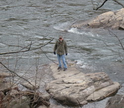
But the river changes and the "low water mark" defines the MD line, whenever/wherever that is. It's a 3Pt of the 3rd kind - nebulous - so don't count on locating the precise junction for an album shot as myself pictured above on that rock that I estimated to be much closer to accurate than the 340 VA welcome sign.
Note: There are several steep, rooty, rocky, muddy, trash-littered paths downhill to the Potomac, and a tangle of tree debris and slippery rocks on the lower bank. Use care here and on 340 which is highly trafficked and fast.
The only place to park along busy US340 is in the southbound direction, just after crossing the Potomac at the Potoma Wayside. The tri-point is West (southbound) of the wayside, somewhere close to the "Welcome to West Virginia" sign. The river bank over and near the tri-point is littered with driftwood and other storm debris. According to the NPS, the actual location of the tri-point is on a narrow strip of private land. It was unclear how to contact the landowner for permission.
Update - Dec 26, 2017 - Frank Sutman
Cross the Potomac River on US 340 into Virginia. Directly after the bridge turn right into the Potoma Wayside parking area. Walk very carefully along the road way for approximately 1/3 of a mile. There is a shoulder but it is narrow. Just after passing the "Welcome to Virginia" sign (opposite direction), look for a triangular concrete survey post behind the guardrail. The VA-WV state line benchmark is close by. Carefully descend the steep river bank directly below the benchmark. Carefully traverse the flood debris and gain access to the rocky river bank. I closely examined the river bank in both directions but could find no additional markers.