 |
|
Photos: Flickr, Loc.alize.us, Bing, Google
Videos: Vimeo, Youtube
Weather: NWS Forecase, NOAA Snow Depth
Nearby POI: Opencaching.us, Waymarking.com
Nearby Highpoints:
92mi/148km - Mount Davis, PA
115mi/185km - Backbone Mountain (Hoye Crest), MD
144mi/232km - Spruce Knob, WV
169mi/272km - Campbell Hill, OH
217mi/349km - Point Reno, DC
232mi/374km - Hoosier High Point, IN
269mi/433km - Ebright Azimuth, DE
280mi/451km - Mount Rogers, VA
287mi/462km - Black Mountain, KY
309mi/497km - High Point, NJ
Nearby Lowpoints:
171mi/276km - Lake Erie, MI
174mi/280km - Potomac River, WV
225mi/362km - Potomac River (MD), DC
252mi/405km - Ohio River, OH
275mi/442km - Delaware River, PA
Nearby Tripoints:
84mi/135km - #30 MD-PA-WV
116mi/187km - #112 OH-ON-PA
135mi/218km - #113 NY-ON-PA
163mi/262km - #111 MI-OH-ON
174mi/280km - #31 MD-VA-WV
189mi/304km - #71 KY-OH-WV
216mi/347km - #32.1 DC-MD-VA (North)
225mi/362km - #32.2 DC-MD-VA (South)
228mi/367km - #29 KY-VA-WV
235mi/378km - #22 IN-MI-OH
252mi/405km - #70 IN-KY-OH
258mi/415km - #33 DE-MD-PA
275mi/443km - #73 DE-NJ-PA
287mi/462km - #28 NC-TN-VA
308mi/495km - #34 NJ-NY-PA
The Corner Corner: http://www.bjbsoftware.com/corners/pointdetail.php3?point=65
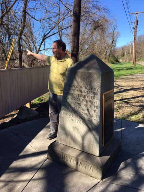
Wikipedia notes: Technically the beginning point of the US Public Land Survey although the actual monument is 1112 feet north of the tripoint due to the tripoint's current location under water.
Wiki article: Beginning_Point_of_the_U.S._Public_Land_Survey
HPC Forum: #72 OH-PA-WV
Although this tripoint is now in the Ohio River, (because of a dam downstream), there is an interesting monument on the Ohio - Pennslyvania line at the side of the PA-68 (OH-39) road. The monument, together with two explanatory signs, documents a historic surveying reference point. The inscription indicates that a spot 1112 feet south of the monument, and at what at that time was the edge of the Ohio River, was the point of beginning for surveying the public lands of the United States. There, on September 30, 1785, Thomas Hutchins, First Geographer of the United States, began the Geographers Line of the Seven Ranges. The original marker, which has been long lost, was on the colonial boundary between Virginia and Pennslyvania on the north bank of the Ohio River.