 |
|
PID=GG0666 (NGS Datasheet)
Maps: [Sat] Google, Bing [Topo] Acme, Gmap4 MyTopo [Peaks] ListOfJohn, Summitpost
Photos: Flickr, Loc.alize.us, Bing, Google
Videos: Vimeo, Youtube
Weather: NWS Forecase, NOAA Snow Depth
Nearby POI: Opencaching.us, Waymarking.com
Nearby Highpoints:
107mi/172km - Magazine Mountain (Signal Hill), AR
227mi/365km - Taum Sauk Mountain, MO
298mi/480km - Driskill Mountain, LA
Nearby Lowpoints:
64mi/103km - Verdigris River, KS
177mi/285km - Little River, OK
239mi/385km - Saint Francis River, MO
245mi/394km - Missouri River, NE
263mi/424km - Mississippi River, TN
281mi/453km - Ouachita River, AR
290mi/466km - Mississippi River, KY
305mi/491km - Mississippi River, IL
Nearby Tripoints:
34mi/55km - #19 KS-MO-OK
198mi/318km - #56 AR-OK-TX
243mi/391km - #21 AR-LA-TX
245mi/394km - #55 KS-MO-NE
263mi/423km - #64 AR-MS-TN
274mi/441km - #63 AR-MO-TN
282mi/454km - #62.1 KY-MO-TN (West)
285mi/459km - #62.2 KY-MO-TN (Middle)
289mi/465km - #62.3 KY-MO-TN (East)
289mi/465km - #54 IA-MO-NE
306mi/492km - #61 IL-KY-MO
311mi/500km - #65 AR-LA-MS
The Corner Corner: http://www.bjbsoftware.com/corners/pointdetail.php3?point=6
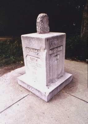
Wikipedia notes: Marked with a stone monument.
Wiki article: OKARMO_Corner
HPC Forum: #20 AR-MO-OK
Newsletter index:
• #101-13q2 p4 [Jim Wright] AR-MO-OK notes and photo
Trip Report - June 21, 1991 - Jack Parsell
 ACCESS ROUTE: From South West City, MO, go S about 1 mile on Route 43 which becomes OK Route 20. The monument is on the W side of the highway just off the shoulder. When the west boundary of Missouri was surveyed in 1823, a large stone post was set to mark the SW corner of the State at a point on latitude N 36° 30'. In 1906 this position was determined to be lat. N 36° 29.267', long W 94° 37.048'. The present monument was erected by the Ozark Culture Club in 1915 with part of the old marker post embedded in it. The whole assembly was installed on a new base in 1955. It is not known whether the present monument assembly was moved to its present location to allow for widening the highway.
Update - June 12, 2000 - Richard L Carey
You can view the trip report at Peakbagging
Update - April 12, 2005 - Brian J Butler
You can view the trip report at The Corner Corner.
Update - Aug 30, 2008 - Bill Wentzel
The access info doesn't vary from the guide via secondary roads. From South West City go south on Rt 43 aprx. 1 mile. This formidable marker, across the road from the "Corner Stone Station," is hard to miss.
Trip Report - May, 2009 - Roger Simpson
You can view the trip report at "Simpson Family OK trip" [bottom of the page].
Update - Sep 2, 2017 - Jimmy Emerson
 |
 |