 |
|
PID=MQ0481 (NGS Datasheet)
Maps: [Sat] Google, Bing [Topo] Acme, Gmap4 MyTopo [Peaks] ListOfJohn, Summitpost
Photos: Flickr, Loc.alize.us, Bing, Google
Videos: Vimeo, Youtube
Weather: NWS Forecase, NOAA Snow Depth
Nearby POI: Opencaching.us, Waymarking.com
Nearby Highpoints:
71mi/114km - Kings Peak, UT
154mi/248km - Gannett Peak, WY
190mi/305km - Mount Elbert, CO
262mi/421km - Panorama Point, NE
290mi/467km - Granite Peak, MT
Nearby Tripoints:
124mi/200km - #6 ID-UT-WY
260mi/419km - #12 CO-NE-WY
261mi/420km - #5 ID-MT-WY
267mi/430km - #3 ID-NV-UT
277mi/445km - #8 AZ-CO-NM-UT
291mi/469km - #11 NE-SD-WY
The Corner Corner: http://www.bjbsoftware.com/corners/pointdetail.php3?point=18
HPC Forum: #7 CO-UT-WY
Newsletter index:
• #69-05q2 p25 [Bob Whitney] CO-UT-WY notes
• #81-08q2 p29 [Jeff Senten] 5 Utah tripoints in 24:46 - youtube.com/watch?v=0a95hvE57wg
• #103-13q4 p33 [Jimmy Emerson] CO-UT-WY monument 'is way off the grid'
• #104-14q1 p36 [Jeff Senten] 5 Utah tripoints in 24:46 - Youtube 'cornering utah'
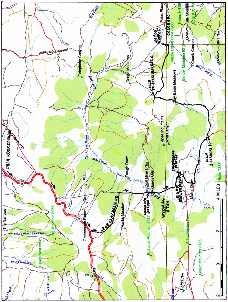
Trip Report - June 26, 1991 - Jack Parsell
 |
 |
PUBLIC LAND SURVEY MONUMENT
Tri State Corner of the States of Wyoming, Utah and Colorado
(Lat. 41° 00' 42.616" N Long. 109° 02' 42.158" Elevation 8402')This point was monumented by surveyor Rolin J. Reeves on July 19, 1879, while completing the survey of the west boundary of the state of Colorado and the east boundary of Utah Territory. The boundary line separating Wyoming Territory from Colorado and Utah Territories was surveyed by US surveyor A V. Richards in 1873.
The original monument was found to be disturbed in 1931, and was remarked by US Cadastral Engineer E. V. Kimmel with a brass tablet seated in a concrete monument.
This monument is one of the comers of the National Rectangular Cadastral Survey System inaugurated in 1785, that has aided the development and orderly settlement of the public lands of the western states. From these monuments, State and Local Governments and private citizens are provided with easily identifiable boundaries. Such monuments serve as a base for the work of private surveyors in making accurate land sub-divisions and descriptions.
Erected by the Kiwanis clubs of Rock Springs, WY, and Craig, CO and the Lions club of Daggett County, UT in cooperation with the Bureau of Land Management, and dedicated on August 21, 1966. Embedded in the concrete base of this monument are some of the original stones which marked the location in 1879.
Update - Summer, 2006 - Bob Whitney
[Ed: also published in #69-05q2-p25].
The approach roads have deteriorated to the point that we recommend a 4WD in all weather. Most people will find it convenient to do #6 and #7 tri-points on the same trip and 4WD might then be used for both.
History of Tripoint and Trip Report - June, 2006 - Dale Sanderson
Dale Sanderson provides history on locating the tripoint at US Ends along with his trip report.
Update - Aug 2, 2013 - Jimmy Emerson
Jimmy Emerson has several photos on Flickr with some descriptions. You can start with this one and the 25 previous [reverse order] photos.