 |
|
PIDs=HV1668, HV1669, HV1670, HV1667 (NGS Datasheet)
Maps: [Sat] Google, Bing [Topo] Acme, Gmap4 MyTopo [Peaks] ListOfJohn, Summitpost
Photos: Flickr, Loc.alize.us, Bing, Google
Videos: Vimeo, Youtube
Weather: NWS Forecase, NOAA Snow Depth
Nearby POI: Opencaching.us, Waymarking.com
Nearby Highpoints:
11mi/18km - Point Reno, DC
109mi/175km - Ebright Azimuth, DE
134mi/215km - Mount Davis, PA
135mi/217km - Spruce Knob, WV
138mi/222km - Backbone Mountain (Hoye Crest), MD
215mi/346km - High Point, NJ
287mi/462km - Mount Rogers, VA
293mi/471km - Mount Frissell-South Slope, CT
Nearby Lowpoints:
1mi/2km - Potomac River (MD), DC
52mi/83km - Potomac River, WV
104mi/168km - Atlantic Ocean, DE
110mi/177km - Atlantic Ocean, MD
111mi/179km - Delaware River, PA
142mi/228km - Atlantic Ocean, VA
199mi/320km - Atlantic Ocean, NJ
218mi/351km - Atlantic Ocean, NY
278mi/448km - Long Island Sound, CT
Nearby Tripoints:
11mi/17km - #32.1 DC-MD-VA (North)
52mi/83km - #31 MD-VA-WV
93mi/149km - #33 DE-MD-PA
111mi/179km - #73 DE-NJ-PA
145mi/234km - #30 MD-PA-WV
216mi/348km - #34 NJ-NY-PA
225mi/362km - #72 OH-PA-WV
281mi/453km - #29 KY-VA-WV
293mi/471km - #35 CT-MA-NY
295mi/474km - #113 NY-ON-PA
296mi/476km - #28 NC-TN-VA
301mi/484km - #71 KY-OH-WV
304mi/490km - #112 OH-ON-PA
The Corner Corner: http://www.bjbsoftware.com/corners/pointdetail.php3?point=23
Wiki article: Boundary_Markers_of_the_Original_District_of_Columbia
HPC Forum: #32.2 DC-MD-VA South
Newsletter index:
• #69-05q2 p26 [Bob Whitney] DC-MD-VA-south notes
• #96-12q1 p26 [Bob Whitney] DC-MD-VA-south notes
• #97-12q2 p17 [Bob Whitney] DC-MD-VA-south history of marker location and current directions
• #103-13q4 p34-35 [Bob Whitney] DC-MD-VA marker history and extensive notes/directions
Trip Report - Feb 17, 1997 - Jack Parsell
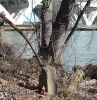
 ACCESS ROUTE: Congress, in 1790 established the District of Columbia. In 1791, President Washington issued a proclamation defining the bounds of the District. The starting point for the defined area was at Jones Point on the Virginia side of the Potomac. Originally 100 sq. miles in area, it was reduced to 68 sq. miles in 1846 when the portion west of the Potomac was ceded back to Virginia. The boundary between the District and Virginia was finally set at the mean low water mark on the Virginia side of the river and following the original pierhead alignment. This is the same situation as MD - WV - VA, where all of the Potomac River is claimed by Maryland. However, in this case, it is a double tri-point since DC has both a northern and a southern junction with VA and MD.
Access to Jones Point, the southern tri-point is very easy since it is in a public park. From VA exit 1 off I 95 just W of the Woodrow Wilson bridge, go N into Alexandria, VA on US 1 a short distance. Turn R on Franklin St. then R on S. Lee St. Follow around under the Woodrow Wilson Bridge to a parking area. From there a short walk will bring you to the marker. The actual tri-point is about 200 feet NE of the marker in the river.
Update - Feb, 1, 2008 - Bill Wentzel
You can view the trip report at The Trek Stop where he gives detailed/updated driving directions. Bill has a Flickr photo album as well.
Update - May, 2017 - Frank Sutman
More recent references to access problems relate to temporary issues with bridge construction, which has been complete for a number of years.