 |
|
PID=AA2136 (NGS Datasheet)
Maps: [Sat] Google, Bing [Topo] Acme, Gmap4 MyTopo [Peaks] ListOfJohn, Summitpost
Photos: Flickr, Loc.alize.us, Bing, Google
Videos: Vimeo, Youtube
Weather: NWS Forecase, NOAA Snow Depth
Nearby POI: Opencaching.us, Waymarking.com
Nearby Highpoints:
91mi/147km - Kings Peak, UT
108mi/174km - Gannett Peak, WY
202mi/325km - Borah Peak, ID
227mi/365km - Granite Peak, MT
Nearby Tripoints:
124mi/200km - #7 CO-UT-WY
153mi/247km - #3 ID-NV-UT
171mi/275km - #5 ID-MT-WY
307mi/494km - #2 ID-NV-OR
The Corner Corner: http://www.bjbsoftware.com/corners/pointdetail.php3?point=38
Wikipedia notes: Marked with a stone.
HPC Forum: #6 ID-UT-WY
Newsletter index:
• #69-05q2 p25 [Bob Whitney] ID-UT-WY notes
• #81-08q2 p29 [Jeff Senten] 5 Utah tripoints in 24:46 - youtube.com/watch?v=0a95hvE57wg
• #104-14q1 p36 [Jeff Senten] 5 Utah tripoints in 24:46 - Youtube 'cornering utah'
Trip Report - July 28, 1997 - Jack Parsell
 |
 |
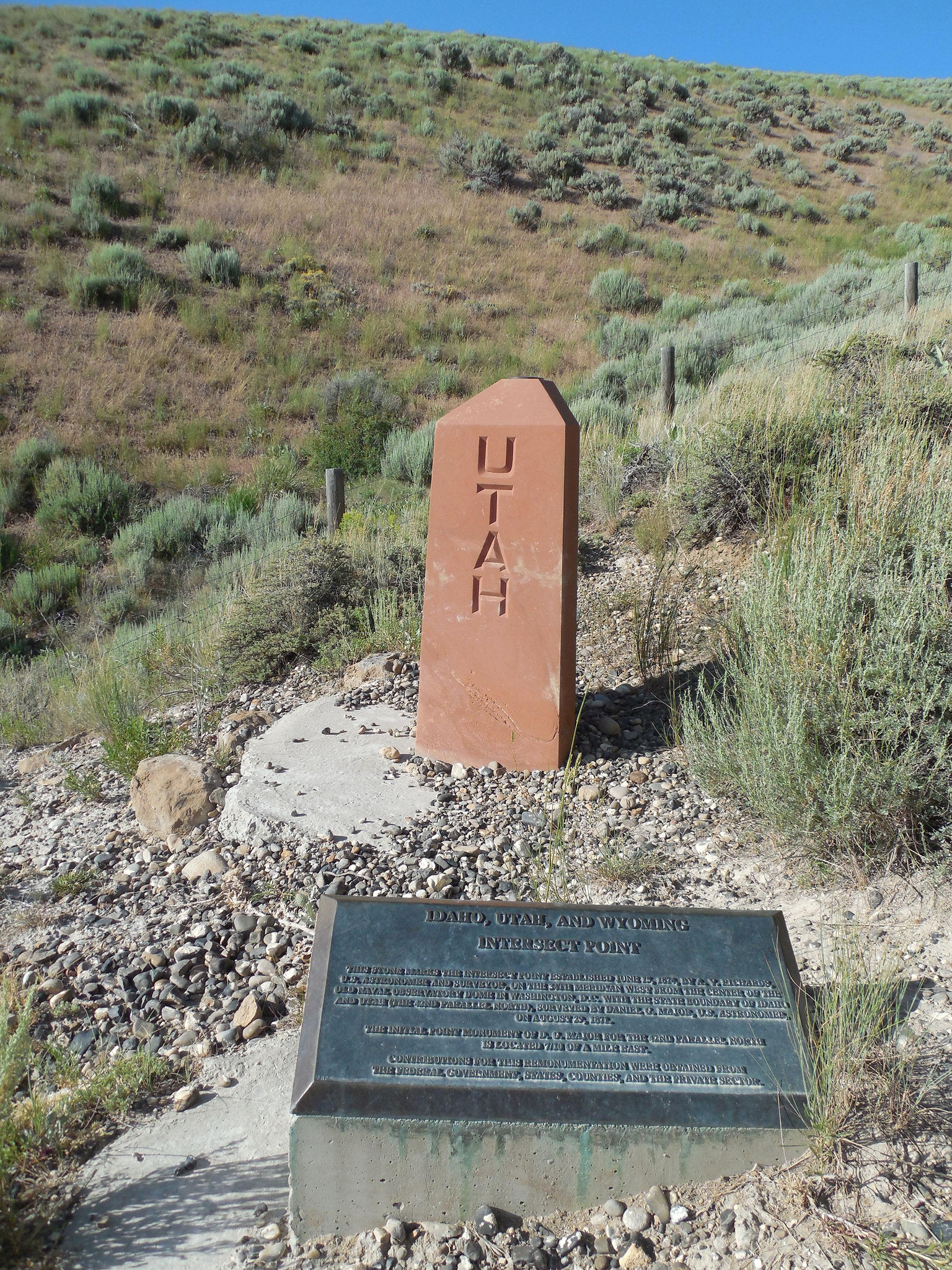
When we were there in 1991 the marker had been knocked down by cattle. Paul Scherbel, Land Surveyor from Big Piney, WY, had found this same situation in 1990 and was instrumental in leading a field investigation project in July, 1991. New monuments were placed in July, 1992, with a sturdy fence around them, and a dedication ceremony was held on August 28, 1992. The plaque mounted beside the new monument reads as follows:
IDAHO, UTAH AND WYOMING INTERSECT POINT THIS STONE MARKS THE INTERSECT POINT ESTABLISHED JUNE 15, 1874, BY A.V.RICHARDS, U.S. ASTRONOMER AND SURVEYOR, ON THE 34TH MERIDIAN WEST FROM THE CENTER OF THE OLD NAVAL OBSERVATORY DOME IN WASHINGTON, D.C. WITH THE STATE BOUNDARY OF IDAHO AND UTAH < THE 42ND PARALLEL NORTH >, SURVEYED BY DANIEL G. MAJOR, U.S. ASTRONOMER, ON AUGUST 29,1871.
THE INITIAL POINT MONUMENT OF D. G. MAJOR FOR THE 42ND PARALLEL NORTH IS LOCATED 7/10 OF A MILE EAST.
CONTRIBUTIONS FOR THIS REMONUMENTATION WERE OBTAINED FROM THE FEDERAL GOVERNMENT, STATES, COUNTIES AND THE PRIVATE SECTOR.
Update - Summer, 2006 - Bob Whitney
[Ed: also published in #69-05q2-p25].
This tripoint probably does not need a 4WD except in very wet weather. However the approaching roads to #7 have deterioratedto the point that we recommend a 4WD in all weather. Most people will find it convenient to do #6 and #7 tri-points on the same trip and 4WD might then be used for both.
Update - Sep 13, 2011 - Jimmy Emerson
Jimmy Emerson has several photos on Flickr providing a visual description of the route to the tri-point marker. You can start with this one and the 21 previous [reverse order] photos.