 |
|
Maps: [Sat] Google, Bing [Topo] Acme, Gmap4 MyTopo [Peaks] ListOfJohn, Summitpost
Photos: Flickr, Loc.alize.us, Bing, Google
Videos: Vimeo, Youtube
Weather: NWS Forecase, NOAA Snow Depth
Nearby POI: Opencaching.us, Waymarking.com
Nearby Highpoints:
37mi/59km - Mount Greylock, MA
70mi/112km - Jerimoth Hill, RI
70mi/113km - Mount Frissell-South Slope, CT
121mi/194km - Mount Marcy, NY
121mi/195km - Mount Washington, NH
127mi/204km - Mount Mansfield, VT
149mi/240km - High Point, NJ
255mi/411km - Ebright Azimuth, DE
281mi/452km - Mount Katahdin (Baxter Peak), ME
Nearby Lowpoints:
80mi/128km - Atlantic Ocean, MA
91mi/146km - Atlantic Ocean, NH
102mi/164km - Long Island Sound, CT
103mi/166km - Atlantic Ocean, RI
132mi/213km - Lake Champlain, VT
160mi/258km - Atlantic Ocean, NY
175mi/282km - Atlantic Ocean, NJ
254mi/408km - Delaware River, PA
266mi/428km - Atlantic Ocean, ME
304mi/489km - Atlantic Ocean, DE
Nearby Tripoints:
41mi/66km - #36 MA-NY-VT
60mi/97km - #38 CT-MA-RI
70mi/113km - #35 CT-MA-NY
103mi/165km - #74 CT-NY-RI
149mi/239km - #34 NJ-NY-PA
164mi/264km - #115 NY-QC-VT
165mi/266km - #116 NH-QC-VT
191mi/307km - #117 ME-NH-QC
192mi/309km - #114 NY-ON-QC
254mi/408km - #73 DE-NJ-PA
270mi/435km - #33 DE-MD-PA
The Corner Corner: http://www.bjbsoftware.com/corners/pointdetail.php3?point=53
Wikipedia notes: Marker is technically on dry land, but buried within river bed due to a dam's construction downstream.
Wiki article: Northern_boundary_of_Massachusetts
HPC Forum: #37 MA-NH-VT
Newsletter index:
• #75-06q4 p14 [Bill Wentzel] MA-NH-VT notes
• #96-12q1 p26 [Bob Whitney] MA-NH-VT notes
Trip Report - July 6, 1993 - Jack Parsell
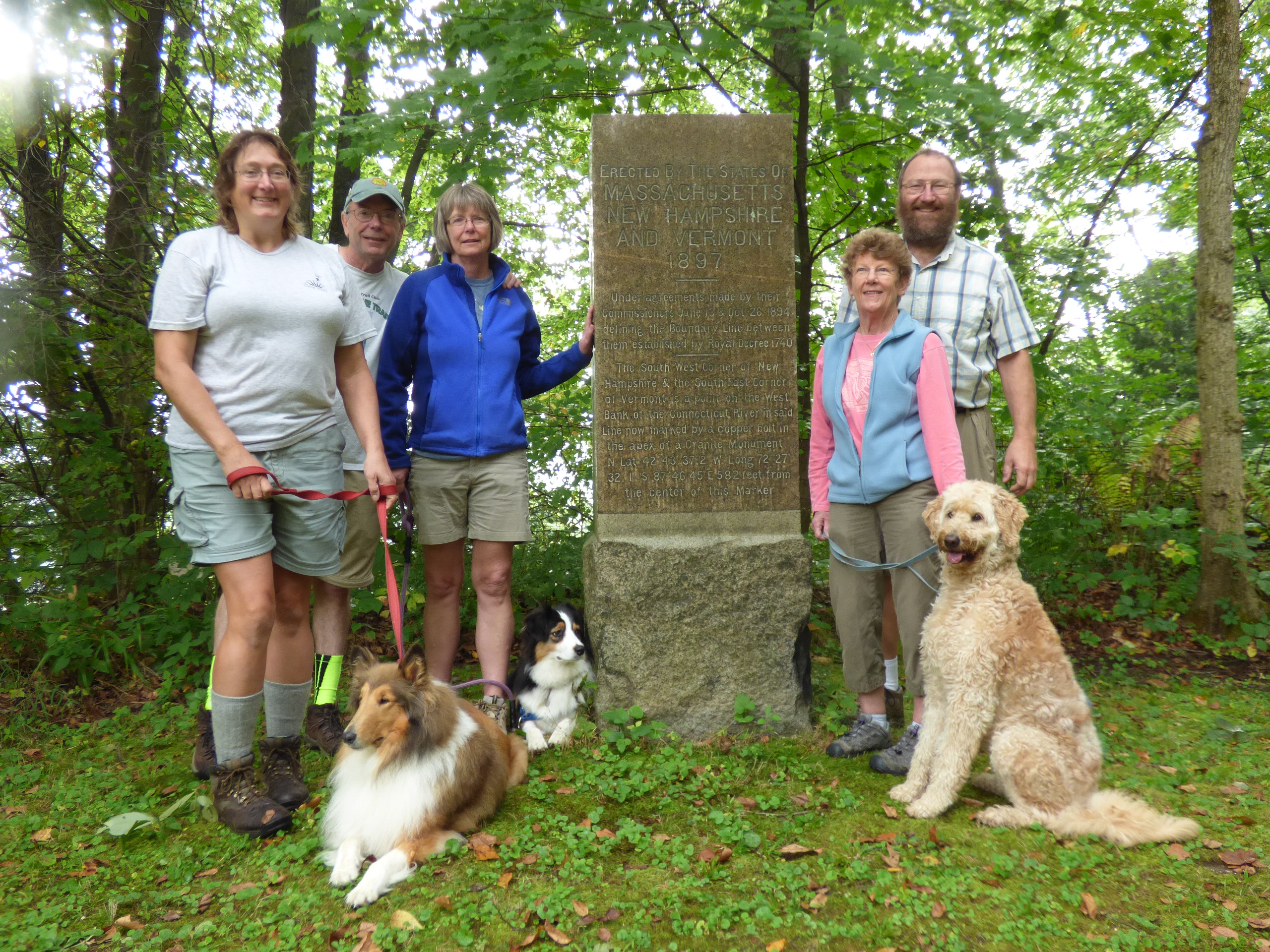
 ACCESS ROUTE: New Hampshire claims all of the Connecticut River along the VT - NH border so the tri-state point should be at the low-water mark, at the MA line. It is, but now it is under water because the water level was raised in the 1960s, when the height of a dam downstream in Turner's Falls, MA was raised. Set high on the bank, above the river, is a large granite monument inscribed, "ERECTED BY THE STATES OF MASSACHUSETTS, NEW HAMPSHIRE AND VERMONT, 1897". But there is indeed a tri-state marker in the river.
The photo shows Willis Parker, Paul Murray and Ernest Murray who uncovered the "Mud Turtle" with the aid of Robert Johnson, surveyor, in Oct, 1969. This marks the precise spot in the Connecticut River where New Hampshire and Vermont meet Massachusetts. The boundary is beneath river waters and was seen beneath the sandy river bottom when the river was lowered for work on the Turners Falls dam. High on the bank stands a dignified polished granite marker featuring the official location of the "Mud Turtle". Photo from the Rivertown Review, Northfield, MA, 1973.
To reach this tri-point, take Route 142, from either MA or VT to a point 0.15 mile S of the VT- MA line, then turn E, and go over a RR overpass. The road bends to the R toward East Northfield Station, but watch for a turn very sharp to the Left (almost 180°), just after the R turn. Take this sharp L, and drive N on a gravel road along the RR tracks to a bend in the road to the R (East), after crossing into VT, (no sign). Turn R into the first driveway, and ask permission from the Murray family to walk to the monument, which is E of their house at the top of the long sloping river bank. The actual tri-state "Mud Turtle" cannot be seen, even from close to the water, since it is now under water. Anyone desiring more information on this interesting tri-point should contact Mr. R. P. Johnston, Maple Street, POB 159, Northfield, MA 01360.
[Ed A2Z #96-12q1-p26: Since the "mud turtle" cannot be seen, Jack suggests a visit to a monument marking the VT-MA border, high on the bank of the Connecticut River.]
Trip Report - ??? - Brian J Butler
You can view the trip report at The Corner Corner.