 |
|
PID=QU0290 (NGS Datasheet)
Maps: [Sat] Google, Bing [Topo] Acme, Gmap4 MyTopo [Peaks] ListOfJohn, Summitpost
Photos: Flickr, Loc.alize.us, Bing, Google
Videos: Vimeo, Youtube
Weather: NWS Forecase, NOAA Snow Depth
Nearby POI: Opencaching.us, Waymarking.com
Nearby Highpoints:
47mi/75km - White Butte, ND
146mi/235km - Black Elk Peak (Harney Peak), SD
284mi/457km - Granite Peak, MT
Nearby Lowpoints:
83mi/133km - Bell Forche River, WY
Nearby Tripoints:
65mi/105km - #10 MT-SD-WY
203mi/327km - #11 NE-SD-WY
211mi/340km - #106 MT-ND-SK
245mi/395km - #107 MB-ND-SK
The Corner Corner: http://www.bjbsoftware.com/corners/pointdetail.php3?point=59
Wikipedia notes: Marked with a red granite stone.
HPC Forum: #9 MT-ND-SD
Newsletter index:
• #69-05q2 p25 [Bob Whitney] MT-ND-SD extensive notes
Trip Report - June 25, 1991 - Jack Parsell
 |
 |
The boundary line between ND and SD which is the seventh standard parallel north, of the public land survey, was surveyed in 1891-92 from the Bois de Sioux River (see also MN-ND-SD) to the MT line. Snyder Hill, in Montana, is a prominent landmark WSW about 1/4 mile and 150 feet higher than the tri-point.
Update - July, 2003 - Jack Parsell
Somebody told me the faint farm road is either too hard to follow or impossible so you have to hike all the way in from the road, north of the bridge over Boxelder Creek.
Update - Summer, 2006 - Bob Whitney
[Ed: also published in #69-05q2-p25].
We could not find the "faint farm road" noted by Jack and locals say it is no longer advisable to use. One approach is to walk in along the river under the iron bridge and then follow a fence on the ND/SD line.
One may also go north from the iron bridge slightly over one mile to the Cox Ranch Road. Take this road west to the ND/MT line. Delorme CD's and gazetteer show a road going in a southerly direction which stars close to that line and takes one to about 1/2 mile from the tripoint. We did not check whether that road is drivable. If that road is not drivable, walking down the ND/MT fence line would involve a longer trip than previously mentioned.
There is a way to drive all the way to the tripoint. We were graciously assisted by locals in the following somewhat complicated drive in. Permission from the Burdicks should be obtained by calling 406-775-6380 or stopping at their ranch (location noted below). Take the Cox Ranch road described above about 7 to 9 miles to a T junction. Go left for 5.1 miles. Turn left at the Burdick mailbox. Their ranch is on the right shortly before one needs to turn left after 1.8 miles. Go 1.5 miles crossing a creek en route and the road then turns right. Go 0.4 miles to find a good farm road on the left, which is not easy to detect from the main road. If you come to a pond with an earthen dam, you have gone too far. Take the farm road 0.8 miles directly to the tripoint. One may also get to the T junction with Cox Ranch Rd. from Baker, MT by consulting a Montana gazetteer. Interestingly the roads through the Burdick ranch are shown in the gazetteer, except for the last 1.2 miles.
Update - July, 2007 - Greg Weiler
Coordinates: N45d 56.716m, W104d 02.733m, elev. 3048 ft
Date Visited: June 25, 1991; Revised July 2007
Access Route: From Buffalo, SD go W 24 miles to Camp Crook, SD. Then go 28 miles N, the first 16 miles paved, the remainder hard packed gravel, to the ND line where a double span iron bridge crosses Boxelder Creek. Continue about 1.5 miles beyond the bridge to a left (W) onto unsigned Cox Ranch Road. Follow this hard packed gravel road, past a facility with a small microwave tower at 1/2 mile, about 3 miles to the MT-ND line where the road becomes loose packed gravel. Continue another 4 miles to a T-intersection. Turn left (S) and go 5.1 miles to the Burdick mailbox on the left. Turn left (E) and go 1.8 miles on a gravel road to the Burdick ranch on the right. Get permission to cross their property (if you haven't done so already by calling them at 406-775-6380).
Follow the dirt road past the turnoff for the ranch for 1.5 miles crossing an unbridged shallow creek en route. The road turns right (E) with a fence line on the left. Go 0.4 miles to a gate in the fence line and proceed N through the gate for the final 0.8 mile along the MT-SD fence line on the right to the tri-point, passing MT-SD marker 203M/65 on the way.
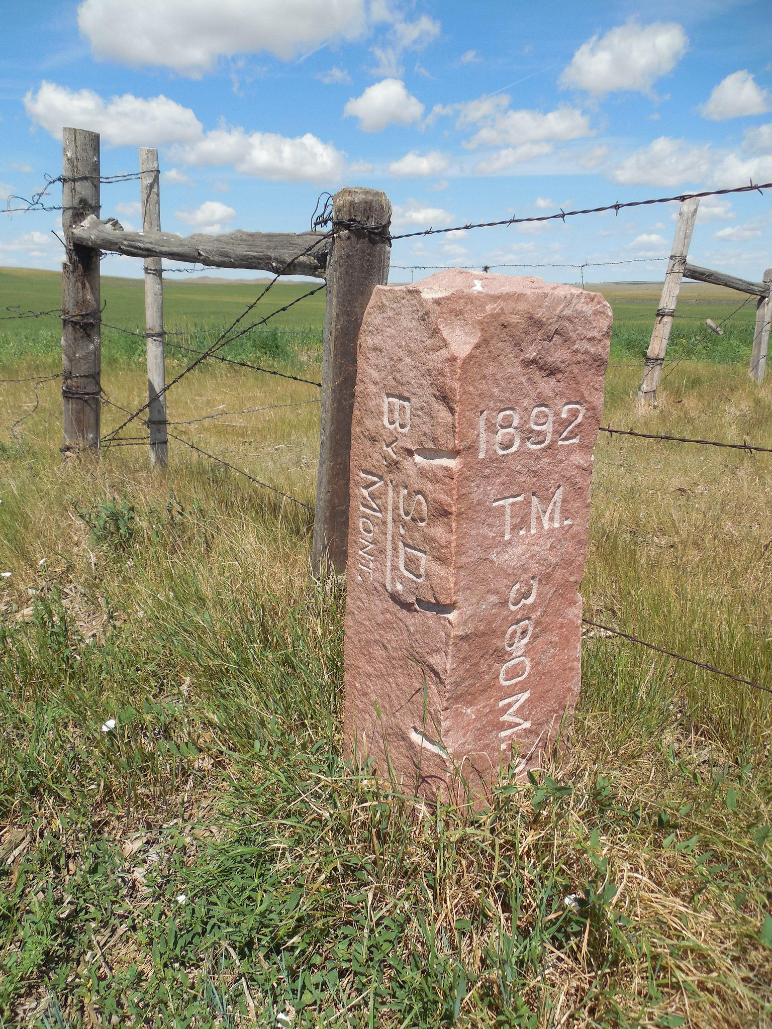
The ND-SD boundary line which is the 7th standard parallel north, of the public land survey, was surveyed in 1891-92 from the Boise de Sioux River (survey details MN-ND-SD), to the MT line. An inscription on the monument reads "1892 T.M. 360M 45.35 C" (Territorial Monument, 360 Miles, 45.35 Chains). Snyder Hill, in MT, is a prominent landmark WSW about 1/4 mile and 150 ft higher than the tripoint.
Update - March, 2017 - Frank Sutman
[more detailed driving directions]: From Buffalo, SD at the intersection of US 85, go W 24 miles on Rt. 20 to Camp Crook, SD. Then go 28 miles N, on Rt. 867, a good dirt road, to the ND line, where a double span iron bridge crosses Boxelder Creek. [Ed: continue with Jack's description].