 |
|
Maps: [Sat] Google, Bing [Topo] Acme, Gmap4 MyTopo [Peaks] ListOfJohn, Summitpost
Photos: Flickr, Loc.alize.us, Bing, Google
Videos: Vimeo, Youtube
Weather: NWS Forecase, NOAA Snow Depth
Nearby POI: Opencaching.us, Waymarking.com
Nearby Highpoints:
65mi/105km - Black Elk Peak (Harney Peak), SD
138mi/222km - Panorama Point, NE
237mi/381km - White Butte, ND
283mi/455km - Gannett Peak, WY
295mi/474km - Mount Sunflower, KS
296mi/476km - Mount Elbert, CO
Nearby Lowpoints:
121mi/194km - Bell Forche River, WY
233mi/375km - Arikaree River, CO
Nearby Tripoints:
138mi/222km - #10 MT-SD-WY
138mi/222km - #12 CO-NE-WY
203mi/327km - #9 MT-ND-SD
232mi/373km - #13 CO-KS-NE
291mi/469km - #7 CO-UT-WY
The Corner Corner: http://www.bjbsoftware.com/corners/pointdetail.php3?point=62
Wikipedia notes: Marked with a stone within a fence.
HPC Forum: #11 NE-SD-WY
Newsletter index:
• #69-05q2 p25 [Bob Whitney] NB-SD-WY notes
• #107-14q4 p38 [Jim Wright] NE-SD-WY updates and photo
Trip Report - June 24, 1991 - Jack Parsell
 |
 |
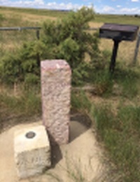
Visitors should stop at the ranch house and get permission and directions for proceeding the remaining mile across the fields to the tri-state point. The low white limestone Chaffee monument is next to the taller quartzite Jenkins monument. A bronze plaque (see text below) is mounted near the monuments.
THE COMMON CORNER TO NEBRASKA AND SOUTH DAKOTA ON WYOMING LINE
The Survey for the boundary between Nebraska and Wyoming territory began August 17th 1869 at the intersection of the 41st Parallel of Latitude and the 27th degree of Longitude W of Washington, DC. Oliver N. Chaffee, Astronomer and Surveyor and his crew surveyed North on the 27th Meridian 138 miles, 22 chains and 67 links, and set a white limestone monument here on September 6th 1869.In 1874, beginning at the Keya Paha River and ending at the Chaffee monument, Chauncey Wiltse surveyed the 43rd Parallel of Latitude between Nebraska and Dakota Territory.
In 1893, Joseph Jenkins retraced the Wiltse Survey and set a quartzite monument here and at 1/2 mile intervals from the Chaffee monument to the Missouri River.
In 1908, Edward F. Stahle retraced the Wyoming-Nebraska boundary and set granite posts at mile internals and brass caps at closing corners.
In recognition of those early Surveyors, the skills they demonstrated and the hardships they endured, we dedicate this Plaque on September 6, 1989.
The geographic position of the Chaffee monument is based on NAD1983 and determined by the Global Positioning System. Latitude N 43000'02.251", Longitude W 104003'11.315", Elevation 1198.4 Meters (3931.70 feet).
Update - July, 2003 - Jack Parsell
Note that Dan Jordon is no longer living, but the family still owns and operates the ranch.
Update - Summer, 2006 - Bob Whitney
[Ed: also published in #69-05q2-p25].
The Jordans are gracious but spend most of their time in Lusk, WY. They still would like anyone going to their ranch to call at 307-334-2520 to let them know your plans. There is a fence along the WY/NE line but don't head for it as soon as you get to the ranch or you will have to climb a very steep and slippery slope. Instead head north keeping a farm building on your right. After gaining some elevation you will see that it is OK to angle towards the fence line.
Update - July, 2007 - Greg Weiler
Coordinates: N43d 00.037m, W104d 03.189m, elev. 3932 ft
Date Visited: June 24, 1991; Revised July 2007
Access Route: From Harrison, NE where Rt 29 goes S turn N onto paved Monroe Canyon Road. In about 8 miles the pavement ends and becomes hard packed gravel. At 10 miles turn left (W) at the Coffee Ranch sign onto Schnurr Road. Continue past the Harris Schnurr Ranch in another 4.5 miles. 2.5 miles further on make a right at a Y at the Schnurr Ranch 96 sign. In another 5 miles cross into Nabraro County, WY. Note that the fence line here to the right (N) intercepts the tri-point about 5 miles away. The 1st turnoff to the right (N) in WY leads to the Tollman Ranch. Take the 2nd turnoff to the right at the Luker and Jordan ranches sign indicating 5 miles to the Jordan Ranch. Follow this hard packed dirt road past the Luker Ranch at I.5 miles. The road finally turns due N very close to the WY-NE fence line. About a mile later the road bends left, crosses a creek (sometimes dry) and goes up to the Jordan Ranch house.
The Jordans spend most of their time in Lusk, WY so be sure to call ahead {307-334-2520) for permission to cross their property. From the house the tri-point is 1.2 miles NE. Hike up the hill to the right behind the barn, past old discarded farm machinery to a gate in the fence line. From here the tri-point is 0.8 miles away. Pass through the gate, angle right toward the WY-NE fence line and follow the fence N to the fenced-in tri-point monuments, passing through another gate in a fence line and Stahle post 138M along the way.
At the tri-point the low white limestone Chaffee monument is next to the taller quartzite Jenkins monument. A bronze plaque (see text above) is mounted near the monuments. Be sure to sign the visitor register.
Newsletter - #107-14q4-p38 - Jim Wright
 There isn't anything to add to Jack's description of how to get to this tripoint other than the road itself. Parts of the 15 mile road are gravel, but several parts are simply dirt with tall weeds growing in the middle of the road. My small car made it because the roads were dry, but I frequently had to straddle deep tire-ruts in the road and I could hear the weeds hitting my bumper and rubbing along the bottom of the car. A truck of SUV would be preferable, especially if the road is wet. The tripoint is on private property call the Jordan Ranch, currently leased by a pleasant gentleman named Trevor. Trevor took me to the tripoint in his truck to save me the hike.