


Pete Anderson will be leading a trip to the High Point via the Appalachian Trail.
Here’s Peter’s 6 meg Powerpoint presentation on the trailheads.
Photos of High Point trailheads
Meet at 8:30 AM, Saturday, August 1, in the Hunts Landing Hotel lobby to car pool to the parking at the headquarters (there is limited parking).
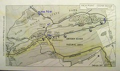
Parking areas for three trails to the NJ state highpoint
1- AT access on Sussex County 519 in NJ
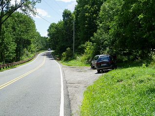
Southbound off I-84 at exit 2, signed as Mountain Rd; from the intersection of US 6 and Orange County 55, drive south for 3.4 miles to small parking area on the west / right side of road; it isn’t marked. This parking area is soon after crossing into New Jersey as indicated by the road changing to Sussex County 519.
Northbound off NJ 23 on Sussex County 519; this road junction is 1.0 mile east on NJ 23 from the High Point State Park visitor center. Drive north 2.4 miles to the small unmarked parking area on the left; this is soon after milepost 88.
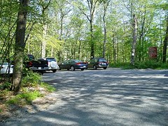
2- AT access near the High Point State Park visitor center (limited parking, short-term at the visitor center).

0.1 mile east of the visitor center on the south side of NJ 23 a sign indicates parking for the Appalachian Trail; don’t drive to the maintenance buildings. Turn here and drive about 100 feet to the large parking area on the right; there is room for about 30 vehicles, depending on how efficiently people park their vehicle.
3- Steeny Kill Trail, lake, and parking area.
Northbound from the HPSP visitor center – drive 1.5 miles to the Steeny Kill Lake boat ramp turnoff on the right side of the road. The sign for this dirt road isn’t visible until you are at it. After you can no longer see the lake, the dirt road will soon appear, but is easily missed, especially if driving too fast on this curving, downhill section of the road.
Southbound from NJ 23 and I-84 junction – drive south 2.8 miles on NJ 23; the sign for Steeny Kill Lake boat ramp is on your left. The road is curving and uphill with traffic wanting to ‘go fast,’ so take care while looking for the somewhat small and obscure sign indicating the boat ramp.
For all three parking areas and trailheads, there are no ‘restroom facilities’ nor water available; plan accordingly. Restrooms and water are available at the High Point State Park visitor center.
Hiking the AT northbound from the AT access on NJ 23.
From the large AT parking area, walk towards the visitor center, through the short distance in the woods. When out of the woods and at the mowed lawn area, with the visitor center visible, look across NJ 23 to the large field. The AT crosses NJ 23 “at the right side” of this open area and follows the right side of the field to the woods at the ‘north side.’ The is an AT trail maker at the road and a sign where the trail enters to woods. The entire AT is marked using white paint makers that are about 6” x 3” – these will indicate the trail wherever you are hiking the AT.
Most of the AT for the next mile is undulating, with minimal elevation change. There is one short, steep climb prior to reaching the viewing platform. Just after the viewing platform, remain ‘on the ridge;’ don’t follow the trail to the left that loses elevation rapidly to a paved road. You will soon have another wonderful view of the highpoint monument and then the trail will lose elevation to an unmarked trail junction. The only indication of this trail junction is the appearance of trail marker that is a red-n-green circle surrounded by white. The AT will continue to the right and parking area on Sussex County 519.
Use the red-n-green trail to access the highpoint area and monument; note that there appears to be two ‘of these trails,’ both will access the road to the monument. Please don’t hike the road to the monument due to the curving, uphill ‘lay of the land’ – cars on the road and hikers on the trail.
Follow the red-n-green trail that is ahead of you, not to the left. About half-way to the road the trail turns to the left; this left turn isn’t obvious. Cross the access road and soon make a right onto an old road that is the trail. Gaining elevation rapidly, the monument will soon be in view. Enjoy attaining the highest, naturally occurring elevation in New Jersey!