Issue #107 of “Apex to Zenith” Fourth Quarter 2014

Topic Page
50 Completers
• Christian Goebel
• Robert Kay
2, 4 – 6
Article – Arizona’s Humphreys Peak 26 – 27
Article – Discovering Tri-state Points 39
Article – Freddie Carter 10
Article – Highpoint Geology 31
Article – Highpoint Handstands 43
Article – Indiana’s HP revealed 11, 13
Article – Rhode Island 7 – 9
Article – The Northern Marianas 14 – 17
Call for Nominations – Directors 19
County Highpointer 20 – 21
Crossword 41
Editor’s Note 3
Errata 18
Highpoint Updates
• Arizona – Humphreys Peak
• Florida – Britton Hill
• Illinois – Charles Mound
• Indiana – Hoosier High Point
• Mississippi – Woodall Mountain
• Rhode Island – Jerimoth Hill
• South Dakota – Black Elk Peak / Harney Peak
• Utah – Kings Peak
11 – 13
Highpointers Foundation 36 – 37
IOWA 2015 22 – 25
Klimbin’ Kollaborator 18
Le Cache 18
Lowpoints – Connard Hogan completes 40
MONTANA 2016 18
Membership Benefits 2
Memorabilia 37
Merc 28 – 29
Milestones 32 – 35
More Than 50 6
New Members 19
President’s Message 18
S.O.S. #34 Staying Found – part 2 of 6 30 – 31
Tri-state Points
• #10 MT-SD-WY
• #11 NE-SD-WY
• #17 MN-ND-SD
• #18 IA-MN-SD
38
World HPs – Europe 42

If you are interested in this back issue, please contact the newsletter editor (newsletter@highpointers.org).

CKTEST Lowpoint Guide

Only admnistrator owned posts can execute the [includeme] shortcode. This message is shown only to administrators.

“[low baritone] Swing low … [kid’s voice] Happy feet” – okay it doesn’t quite work. It’s all downhill from the highpoint to the lowpoint – so to speak.

[Ed: Paragraphs in italics are taken verbatim or heavily paraphrased from Jack Parsell’s book “Guide to the Lowpoints of the United States” which is the basis for this guide.]

While visiting a state for its highpoint, you might consider visiting other geographic extremities like its lowpoint. The USGS publishes the “Elevations and Distances in the United States” which is nicely summarized in Wikipedia’s “List of U.S. states by elevation“.

DISCLAIMER

Low-pointing requires some venturing into remote areas across inhospitable terrain (heavy brush and poison oak/ivy are quite common) and private property (please contact land-owner before entering). As lowpoint completer #3 Bob Nungester says, “Lowpoints aren’t for everone.”

Introduction

After reaching the highest print in each of the 50 US states, a natural follow-up was to visit all of the state law points. Jack Parsell accomplished this mostly during the years 1988 through 1991. Visits to beaches in some of the coastal states occurred at earlier times, as much as forty years ago.

This guide provides directions and hints for getting to the interior low points. Of the 51 low points (including DC), 24 are currently considered coastal – being at sea level for states bordering the Atlantic, Pacific and Gulf of Mexico, or lake levels for some of the interior states. Access to any of these low points is simply a matter of going to the beach or shore of your choice and dipping your foot in the water.

This edition includes the new low point for Colorado [FIXME insert usends.com link] and a corrected elevation for Utah. A spot has been found in extreme SE Texas [Ed: Stell-Lind Banco 128] that is about 1 foot below sea level. Another area near Everett, WA, has been found on topo maps to be -3ft. These will be investigated further and results reported in future editions.

Alaska, California and Louisiana have locations below sea level, so their coastal beaches do not count as low points. Note that the -4ft level for Alaska has not been verified by USGS, so any sea level visit is still acceptable. As mentioned above, possible new low points for Texas and Washington may remove their coastal low point status. The interior state low points are usually located on river banks or lakes where the state line reaches or crosses the water. Two of the states, New Mexico and South Dakota have low points which used to be on river, but now are on lakes because of dams downstream in the next state. Because of their unique nature these two are included with the interior states and directions for access are given.

Precise locations are often difficult to determine. In many instances state line fences stop at the edge of the river flood plain, and a compass and/or GPS must be followed for the remaining distance to the water. As contrasted with mountain summits which are usually on public land, many of the interior low points are on privately owned property. In some instances it is difficult to determine the ownership and to obtain permission to go on the property. Information in this regard is given in the directions for several of the low points. Finally, another factor of concern is river water level. Many of the low points are situated on flood plains which during periods of high water are inundated and inaccessible. It is best to go to many of these locations during low water periods.

In Appendix – Interview with Jack Parsell we have an excerpt of an interview with Jack Parsell about low-pointing. What got you started? Are there any rules? What is your favorite lowpoint? etc.

Resources

There are several websites with a focus on low-pointing:

There are several websites with random posts on low-pointing including but not limited to:

  • Death Valley Adventures – Steve Hall documents the actual lowest point in California.
  • US Ends.com – Dale Sanderson documents the history and analysis for designating Colorado’s lowest elevation.
  • CN Traveler – Ken Jennings article on California’s lowest and highest points being in Inyo County.
  • Deseret News – Lynn Arave’s article on Utah’s lowest point.
  • AlansFactoryOutlet.com – Offers a nice infographic showing each state’s highpoint and lowpoint.

The Highpointers Club offers several resources as well:

You may also want to read low-pointing articles in the “Apex to Zenith” newsletter. For example, “Lowpoint Adventures” by Bob Nungester (Issue #105 Second Quarter 2014) or “Connard Hogan, Completer of 50 State Highpoints and 50 State Lowpoints” (Issue #107 Fourth Quarter 2014).

Finally, you can see who has completed the 50 state lowpoints at our “Lowpoint Score Board” page.

Trivia

Before we get to the map and table, here are some trivia questions (answers at the bottom):
Q1: How many states have their lowpoint below sea level?
Q2: Which state has the highest lowpoint?
Q3: Which state has the shortest distance between its highpoint and lowpoint?
Q4: Which state has the longest distance between its highpoing and lowpoint?

You may also be interested in a “US States Lowest Points online quiz hosted on sporcle.com.

About this Guide

This page, “US Lowpoint Guide”, is an aggregation of multiple sources. It is largely based on Jack’s guide book. It includes several updates/clarifications based on trip reports from various contributors. Please contact us at guides@highpointers.org if you have any suggestions or updates.

You will see many lowpoints are defined by water (river, ocean, lake). Where do you define the lowest point for North Carolina when its the Atlantic Ocean? This guide arbitrary chooses the closest point (as the crow flies) to the respective highpoint. In some cases it also lists an alternate closer equivalent point (eg, Puget Sound and Pacific Ocean for Washington state).

This page contains three major sections below. The first contains a map showing each state’s highpoint, lowpoint(s) and lines drawn between them. Below the map is a large table listing all the lowpoints and their associated data. The middle section is the collection of show/hide (open/close) information panels with details for each lowpoint. This includes trip reports and updates as well as data like elevation, location, etc. The last section is a series of appendices such as trivia answers, an interview with Jack Parsell on low-pointing, etc.


Only admnistrator owned posts can execute the [includeme] shortcode. This message is shown only to administrators.

/ – Highpoints : – Lowpoints

This table provides summary information about all the lowpoints.
State – Those with an * indicate alternate but closer lowpoint to the highpoint
     the link jumps you to the information panel
Location – Location of low point usually specified by USGS/Wikipedia
Low Elev – Elevation of lowpoint
     the link takes you to our forum discussion group
High Elev – Elevation of the state’s highpoint
Hi-Low Span – Difference in elevation between highpoint and lowpoint
Hi-Low Distance – Distance in miles between the highpoint and lowpoint
[You may re-sort this table by clicking the small arrows found in the column headers.]

Only admnistrator owned posts can execute the [includeme] shortcode. This message is shown only to administrators.
State Location Low Elev High Elev Hi-Low Span Hi-Low Distance (miles)

Only admnistrator owned posts can execute the [includeme] shortcode. This message is shown only to administrators.

This section contains information panels for each lowpoint. Click on the name of the lowpoint and a panel opens up presenting the details about the lowpoint. This includes Jack’s trip report and more recent trip reports or updates if available. You will also find additional information such as elevation, location, etc.

Only admnistrator owned posts can execute the [includeme] shortcode. This message is shown only to administrators.

Please contact us at guides@highpointers.org if you have any suggestions or trip reports/updates you would like to share.


Only admnistrator owned posts can execute the [includeme] shortcode. This message is shown only to administrators.

Appendix – Trivia Answers

The answers to the trivia questions are:
A1: 2-3 – California (-282 ft) and Louisiana (-8 ft) and Alaska* (-4 ft)
A2: Colorado at 3315 feet
A3: Minnesota at 12.8 miles (US Virgin Islands at 0.87 miles if you include the territories)
A4: Texas at 546 miles

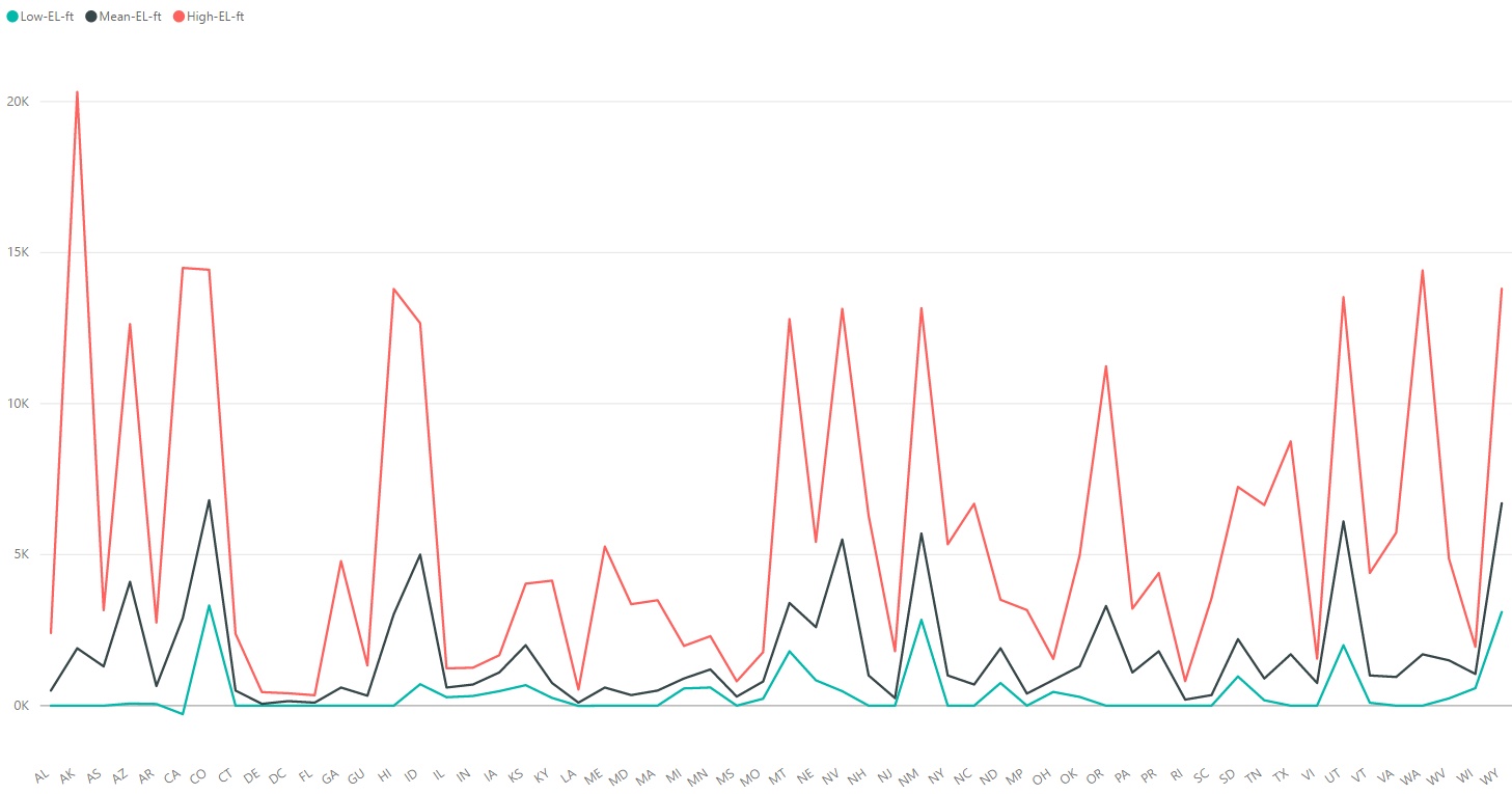
Appendix – Highest, Lowest and Mean Elevations

This graph shows shows the highpoint (red) and lowpoint (green) elevation along with the mean (black) elevation of each state/populated-territory. Click on the image to view in full scale.

Appendix – Flattest State

Back in 2003 you may remember that some scientists determined that Kansas is flatter than a pancake. But is Kansas the flattest state? Looking at the span (highpoint elevation – lowpoint elevation) we see that Florida is the flattest state at 345 feet (with Alaska the least flat at 20320 feet). Alternatively, we could look at the slope between the highpoint and lowpoint. In this case Illinois is the flattest with a slope of 0.027 degrees (with Hawaii the least flat at a whopping 8.54 degrees – although American Samoa blows the competition away at 30.16 degrees). In 2014, University of Kansas researchers did a far more rigorous analysis and confirmed that Florida is the flattest state, while Kansas was only the seventh flattest state.

You may also want to read the newsletter article “The Flattest US States? Not What You Think” (Issue #105 Second Quarter 2014) and the associated National Geographic article.

Appendix – Interview with Jack Parsell

[Ed: This is an excerpt of an interview with Jack and Joyce Parsell by Roger Rowlett. The full interview was featured in Issue #60 – First Quarter 2003 of the “Apex to Zenith” newsletter.]

Why did you start doing low points after completing your 50th state (Gannnett) in 1989?

Somebody said what are you going to do now that you’ve done all the highpoints. I was joking, and said, I guess I will try all the low points. But earlier, in 1988 when we were going out to ski at Red Lodge we stopped at the Wyoming low point which is where the Belle Fourche River flows into South Dakota. We had to hike down along the boundary line fence. We ran into a rancher. He didn’t mind us going down there but he said, “Watch out for the bulls.” So that was the real start of it.

Are there any rules for “lowpointing”?

I don’t think anybody has ever done them before so I made up the rules on my own. The high tide mark is the point we count for states with sea level elevations. For interior lakes it is the high water level.

Most of the interior lowpoints are where rivers exit into adjoining states and you often have to follow a fence down to the river. On larger rivers the fences don’t go all the way and you have to follow a compass heading. I don’t know how precise that is. We usually try to get down to the water itself. We stick a toe in the water. There’s no definition on how high the water has to be.

What are some of your favorite low points?

We went to the lowpoint of Arizona which is the Colorado River where it runs into Mexico. When we were there there wasn’t a drop of water in it. All the water was in an irrigation ditch which runs parallel to the river. We just walked out in the middle of the dry riverbed. It was quite wide, probably 200 yards.

In fact that’s where the picture on the cover of the low points book was taken. We had checked with the immigration officials. They couldn’t figure out why anyone would want to do that. I probably wouldn’t want to try it now with the current border problems.

What are some other interesting low points?

The ocean beaches of course are quite nice. We visited the ocean or lake low points in each state. Our favorite beach low point was where Lewis & Clark ended their journey in Oregon.

Nevada used to be difficult to access. It is at the very southern tip on the Colorado River. But recently I got an email saying that the Indians have built a casino there and it’s just a few hundred yards from the casino to the low point, and there is now a bridge across the river. It’s also a tristate-point if you go out in the middle of the river.

CKTEST pdf views

I did some research and there are a few options for us. Take a look and think about it. Remember that people can simply do a screen capture to copy/print the PDFs f they want. Alternatively, what I do is right-click “View page source” and find the URL to the PDF/JPG. I then enter that address directly into the browser and download the PDF/JPG. There isn’t much you can do to stop that. The best I’ve seen is for us to put all the PDFs/JPGs into a special directory and add a .htaccess file so if someone tries to directly browse to the JPG/PDF, they get a 403 Forbidden error. We get access to them by using a special servedata.php/?file=xxx script which has back-door access to that special directory.

ID States
Type
Elev Location
1 OR, CA, NV
Land – 2mi
5285, 5293wp? 41.9947, -119.9994
2 OR, ID, NV
Land – 1mi
5274, 5277wp? 42.0000, -117.0263
3 ID, NV, UT
Land – 3mi
5233, 5230wp? 41.9934, -114.0415
4 NV, UT, AZ
Land – 4mi
2703, 2557wp? 37.0000, -114.0500
5 MT, ID, WY
Land – 4-10mi
8330, 8347wp? 44.4780, -111.0532
6 ID, UT, WY
Land – 0.57mi
7057 42.0016, -111.0468
7 WY, UT, CO
Land – 0ft
8408, 8402wp? 41.0005, -109.0500
8 UT, CO, AZ, NM
Land – 0ft
4866, 4870wp? 36.9988, -109.0452
9 MT, ND, SD
Land – 1.6mi
3048, 3055wp? 45.9449, -104.0454
10 MT, WY, SD
Land – 0.5mi
3422, 3428wp? 44.9973, -104.0578
11 WY, SD, NE
Land – 1mi
3932 43.0003, -104,0532
12 WY, NE, CO
Land – 0ft
5386, 5382wp? 41.0016, -104.0532
13 CO, NE, KS
Land – 0ft
3444, 3447wp? 40.0003, -102.0516
14 CO, NM, OK
Land – 0ft
4445, 4444wp? 37.0000, -103.0022
15 NM, OK, TX
Land – 0ft
4714, 4712wp? 36.5002, -103.0024
16 CO, KS, OK
Land – 0ft
3687, 3692wp? 36.9927, -102.0419
17 ND, SD, MN
Land – 0ft
970, 972wp? 45.9348, -96.5632
18 SD, MN, IA
Land – 0ft
1410, 1413wp? 43.5001, -96.4532
19 KS, OK, MO
Land – 0ft
1024, 1016wp? 36.9985, -94.6178
20 OK, MO, AR
Land – 0ft
1129, 1049wp? 36.4993, -94.6178
21 TX, AR, LA
Land – 40ft
226, 224wp? 33.0191, -94.0429
22 IN, MI, OH
Land – 0ft
1066, 1071wp? 41.6960, -84.8060
23 TN, AL, GA
Land – 600ft
720, 725wp? 34.9844, -85.6052
24 AL, FL, GA
Land – 0.25mi
70, 83wp? 31.0005, -85.0008
25 TN, NC, GA
Land – 600ft
1760, 1758wp? 34.9878, -84.1918
26 NC, GA, SC
Land – 3.5mi
2149, 2147wp? 35.0005, -83.1083
27 KY, VA, TN
Land – 1.1mi
1987, 1988wp? 36.6006, -83.6753
28 TN, VA, NC
Land – 1.5mi
4628, 4636wp? 36.5879, -81.6774
29 KY, VA, WV
Land – 0.6mi
827, 828wp? 37.5378, -81.9680
30 PA, WV, MD
Land – 0.57mi
2320, 2328wp? 39.7210, -79.4768
31 MD, WV, VA
Land – 0.25mi
260, 254wp? 39.3211, -77.7190
32.1 VA, DC, MD
Land – 175ft?
10, 23wp? 38.9341, -77.1199
32.2 VA, DC, MD
Land – 640ft?
8, 0wp? 38.7909, -77.0395
33 PA, MD, DE
Land – 800ft
255, 236wp? 39.7219, -75.7886
34 NY, PA, NJ
Land – 0ft
420, 409wp? 41.3572, -74.6946
35 MA, NY, CT
Land – 1.5mi
2146, 2151wp? 42.0495, -73.4874
36 VT, NY, MA
Land – 1mi
1417, 1436wp? 42.7457, -73.2649
37 VT, NH, MA
Land – 775ft
197, 181wp? 42.7268, -72.4584
38 CT, MA, RI
Land – 0.8mi
630, 625wp? 42.0079, -71.7990
51 WA, OR, ID
Water – 300ft
866 tbd
52 CA, NV, AZ
Water – 130ft
478 tbd
53 SD, NE, IA
Water – 350ft
1101 tbd
54 NE, IA, MO
Water – 275ft
907 tbd
55 NE, KS, MO
Water – 350ft
853 tbd
56 OK, AR, TX
Water – 300ft
292 tbd
57 MN, WI, MI
Water – 25mi
600 tbd
58 MN, IA, WI
Water – 525ft
621 tbd
59 IA, WI, IL
Water – 325ft
604 tbd
60 IA, MO, IL
Water – 0.25mi
483 tbd
61 IL, KY, MO
Water – 0.25mi
292 tbd
62 MO, KY, TN
Water – 0.25mi
263 tbd
63 MO, AR, TN
Water – 150ft
240 tbd
64 AR, TN, MS
Water – 700ft
189 tbd
65 AR, LA, MS
Water – 690ft
80 tbd
66 TN, MS, AL
Water – 0.25mi
427 tbd
67 WI, IL, MI
Water – 40mi
577 tbd
68 IL, MI, IN
Water – 9.5mi
577 tbd
69 IL, IN, KY
Water – 750ft
347 tbd
70 IN, OH, KY
Water – 700ft
460 tbd
71 OH, KY, WV
Water – 100ft
518 tbd
72 OH, WV, PA
Water – 75ft
665 tbd
73 PA, DE, NJ
Water – 0.5mi
0 tbd
74 CT, RI, NY
Water – 1mi
0 tbd
101 AK, YU, BC
Canada, Land
-99 location
102 BC, WA, ID
Canada, Land
-99 location
103 BC, ID, MT
Canada, Land
-99 location
104 BC, ALB, MT
Canada, Land
-99 location
105 ALB, SAS, MT
Canada, Land
-99 location
106 SAS, MT, ND
Canada, Land
-99 location
107 SAS, MAN, ND
Canada, Land
-99 location
108 MAN, ND, MN
Canada, Water
-99 location
109 MAN, ONT, MN
Canada, Water
-99 location
110 ONT, MN, MI
Canada, Water
-99 location
111 MI, ONT, OH
Canada, Water
-99 location
112 ONT, OH, PA
Canada, Water
-99 location
113 ONT, PA, NY
Canada, Water
-99 location
114 ONT, QUE, NY
Canada, Water
-99 location
115 QUE, NY, VT
Canada, Water
-99 location
116 QUE, VT, NH
Canada, Water
-99 location
117 QUE, NH, ME
Canada, Land
-99 location
118 ME, QUE, NB
Canada, Water
elev location
151 CA, BAJA, AZ
Mexico, Water
-99 location
152 BAJA, AZ, SON
Mexico, Water
-99 location
153 AZ, NM, SON
Mexico, Land
-99 location
154 NM, SON, CHI
Mexico, Land
-99 location
155 NM, TX, CHI
Mexico, Water
-99 location
156 TX, CHI, COA
Mexico, Water
-99 location
157 TX, COA, NL
Mexico, Water
-99 location
158 TX, NL, TAM
Mexico, Water
-99 location

Tripoints Accessible on Land:

  1. Oregon-California-Nevada
  2. Oregon-Idaho-Nevada
  3. Idaho-Nevada-Utah
  4. Nevada-Utah-Arizona
  5. Montana-Idaho-Wyoming
  6. Idaho-Utah-Wyoming
  7. Wyoming-Utah-Colorado
  8. Four Corners (Utah-Colorado-Arizona-New Mexico)
  9. Montana-North Dakota-South Dakota
  10. Montana-Wyoming-South Dakota
  11. Wyoming-South Dakota-Nebraska
  12. Wyoming-Nebraska-Colorado
  13. Colorado-Nebraska-Kansas
  14. Colorado-New Mexico-Oklahoma
  15. New Mexico-Oklahoma-Texas
  16. Colorado-Kansas-Oklahoma
  17. North Dakota-South Dakota-Minnesota
  18. South Dakota-Minnesota-Iowa
  19. Kansas-Oklahoma-Missouri
  20. Oklahoma-Missouri-Arkansas
  21. Texas-Arkansas-Louisiana
  22. Indiana-Michigan-Ohio
  23. Tennessee-Alabama-Georgia
  24. Alabama-Florida-Georgia
  25. Tennessee-North Carolina-Georgia
  26. North Carolina-Georgia-South Carolina
  27. Kentucky-Virginia-Tennessee
  28. Tennessee-Virginia-North Carolina
  29. Kentucky-Virginia-West Virginia
  30. Pennsylvania-West Virginia-Maryland
  31. Maryland-West Virginia-Virginia
  32. Virginia-Washington, D.C.-Maryland
  33. Pennsylvania-Maryland-Delaware
  34. New York-Pennsylvania-New Jersey
  35. Massachusetts-New York-Connecticut
  36. Vermont-New York-Massachusetts
  37. Vermont-New Hampshire-Massachusetts
  38. Connecticut-Massachusetts-Rhode Island

Tripoints Located in Water:

  1. Washington-Oregon-Idaho
  2. California-Nevada-Arizona
  3. South Dakota-Nebraska-Iowa
  4. Nebraska-Iowa-Missouri
  5. Nebraska-Kansas-Missouri
  6. Oklahoma-Arkansas-Texas
  7. Minnesota-Wisconsin-Michigan
  8. Minnesota-Iowa-Wisconsin
  9. Iowa-Wisconsin-Illinois
  10. Iowa-Missouri-Illinois
  11. Illinois-Kentucky-Missouri
  12. Missouri-Kentucky-Tennessee
  13. Missouri-Arkansas-Tennessee
  14. Arkansas-Tennessee-Mississippi
  15. Arkansas-Louisiana-Mississippi
  16. Tennessee-Mississippi-Alabama
  17. Wisconsin-Illinois-Michigan
  18. Illinois-Michigan-Indiana
  19. Illinois-Indiana-Kentucky
  20. Indiana-Ohio-Kentucky
  21. Ohio-Kentucky-West Virginia
  22. Ohio-West Virginia-Pennsylvania
  23. Pennsylvania-Delaware-New Jersey
  24. Connecticut-Rhode Island-New York

United States-Canada Tripoints:

  1. Alaska-Yukon Territory-British Columbia
  2. British Columbia-Washington-Idaho
  3. British Columbia-Idaho-Montana
  4. British Columbia-Alberta-Montana
  5. Alberta-Saskatchewan-Montana
  6. Saskatchewan-Montana-North Dakota
  7. Saskatchewan-Manitoba-North Dakota
  8. Manitoba-North Dakota-Minnesota
  9. Manitoba-Ontario-Minnesota
  10. Ontario-Minnesota-Michigan
  11. Michigan-Ontario-Ohio
  12. Ontario-Ohio-Pennsylvania
  13. Ontario-Pennsylvania-New York
  14. Ontario-Quebec-New York
  15. Quebec-New York-Vermont
  16. Quebec-Vermont-New Hampshire
  17. Quebec-New Hampshire-Maine
  18. Maine-Quebec-New Brunswick

United States-Mexico Tripoints:

  1. California-Baja California-Arizona
  2. Baja California-Arizona-Sonora
  3. Arizona-New Mexico-Sonora
  4. New Mexico-Sonora-Chihuahua
  5. New Mexico-Texas-Chihuahua
  6. Texas-Chihuahua-Coahuila
  7. Texas-Coahuila-Nuevo Leon
  8. Texas-Nuevo Leon-Tamaulipas

DDDDDDDDDDDDDDDDDDDDDDDDDDDDDDDDDDDDDDDDDDDDDDDDDDDDDDDDDDDDDDDDDDDDDDDDDD
DDDDDDDDDDDDDDDDDDDDDDDDDDDDDDDDDDDDDDDDDDDDDDDDDDDDDDDDDDDDDDDDDD
WWWWWWWWWWWWWWWWWWWWWWWWWWWWWWWWWWWWWWWWWWWWWWWWWWWWWWWWWWWWWWWWWWWWWW

ID States
Type
Elev Location Benchmark
Notes
1 OR, CA, NV
Land – 2mi
5285, 5293wp? 41.9947, -119.9994 Boundary Post CA NV OR
Marked with a cairn
2 OR, ID, NV
Land – 1mi
5274, 5277wp? 42.0000, -117.0263 Boundary ID OR NV
Marked with a three-sided stone inscribed with N-I-O on the respective faces
3 ID, NV, UT
Land – 3mi
5233, 5230wp? 41.9934, -114.0415 Three Corners
Private property. Marked with a granite monument inscribed with the respective states’ names
4 NV, UT, AZ
Land – 4mi
2703, 2557wp? 37.0000, -114.0500 Boundary Initial Mon AZ NV UT
 
5 MT, ID, WY
Land – 4-10mi
8330, 8347wp? 44.4780, -111.0532
NOTES
6 ID, UT, WY
Land – 0.57mi
7057 42.0016, -111.0468 Boundary Cor ID UT WY BLM
NOTES
7 WY, UT, CO
Land – 0ft
8408, 8402wp? 41.0005, -109.0500 GLO 28 CO UT WY
Park and look
8 UT, CO, AZ, NM
Land – 0ft
4866, 4870wp? 36.9988, -109.0452 CO UT AZ NM
$3 fee
9 MT, ND, SD
Land – 1.6mi
3048, 3055wp? 45.9449, -104.0454 Boundary Mon 360M
NOTES
10 MT, WY, SD
Land – 0.5mi
3422, 3428wp? 44.9973, -104.0578 NE Corner Wyoming
NOTES
11 WY, SD, NE
Land – 1mi
3932 43.0003, -104,0532 Chaffee Monument
Private property
12 WY, NE, CO
Land – 0ft
5386, 5382wp? 41.0016, -104.0532 Boundary Mon CO NE WY
Park and look
13 CO, NE, KS
Land – 0ft
3444, 3447wp? 40.0003, -102.0516 Boundary Mon CO KS NE
Park and look
14 CO, NM, OK
Land – 0ft
4445, 4444wp? 37.0000, -103.0022 Boundary MI Cor CO NM OK
Park and look
15 NM, OK, TX
Land – 0ft
4714, 4712wp? 36.5002, -103.0024 Texhomex
Park and look
16 CO, KS, OK
Land – 0ft
3687, 3692wp? 36.9927, -102.0419 Boundary Mon CO KS OK
NOTES
17 ND, SD, MN
Land – 0ft
970, 972wp? 45.9348, -96.5632
Park and look. WIKI – not directly marked and most probably within Bois de Sioux River
18 SD, MN, IA
Land – 0ft
1410, 1413wp? 43.5001, -96.4532
NOTES
19 KS, OK, MO
Land – 0ft
1024, 1016wp? 36.9985, -94.6178 Boundary Mon KS MO OK
NOTES
20 OK, MO, AR
Land – 0ft
1129, 1049wp? 36.4993, -94.6178 Bondary Mon AR MO OK
Park and look
21 TX, AR, LA
Land – 40ft
226, 224wp? 33.0191, -94.0429 Boundary Mon AR LA TX
NOTES
22 IN, MI, OH
Land – 0ft
1066, 1071wp? 41.6960, -84.8060 Ohio Mich Bdry Cor WP
NOTES
23 TN, AL, GA
Land – 600ft
720, 725wp? 34.9844, -85.6052 LS 1
NOTES
24 AL, FL, GA
Land – 0.25mi
70, 83wp? 31.0005, -85.0008
Private property
25 TN, NC, GA
Land – 600ft
1760, 1758wp? 34.9878, -84.1918
Private property
26 NC, GA, SC
Land – 3.5mi
2149, 2147wp? 35.0005, -83.1083 Elicott Rock
WIKI – Located in Chatooga River very near marker on land
27 KY, VA, TN
Land – 1.1mi
1987, 1988wp? 36.6006, -83.6753 Virginia Corner 2 Reset
NOTES
28 TN, VA, NC
Land – 1.5mi
4628, 4636wp? 36.5879, -81.6774 North Carolina Corner Reset
Private property
29 KY, VA, WV
Land – 0.6mi
827, 828wp? 37.5378, -81.9680
NOTES
30 PA, WV, MD
Land – 0.57mi
2320, 2328wp? 39.7210, -79.4768 Mon 34
NOTES
31 MD, WV, VA
Land – 0.25mi
260, 254wp? 39.3211, -77.7190
WIKI – unmarked at low water line and almost always submerged
32.1 VA, DC, MD
Land – 175ft?
10, 23wp? 38.9341, -77.1199 VA, DC, MD
Private property
32.2 VA, DC, MD
Land – 640ft?
8, 0wp? 38.7909, -77.0395 Boundry Mark 14 DC VA
NOTES
33 PA, MD, DE
Land – 800ft
255, 236wp? 39.7219, -75.7886 MDP Corner
Private property
34 NY, PA, NJ
Land – 0ft
420, 409wp? 41.3572, -74.6946 Tri States 1942
Waterside
35 MA, NY, CT
Land – 1.5mi
2146, 2151wp? 42.0495, -73.4874 Boundary Bound CT MA NY
NOTES
36 VT, NY, MA
Land – 1mi
1417, 1436wp? 42.7457, -73.2649 Boundary Bound MA NY VT
NOTES
37 VT, NH, MA
Land – 775ft
197, 181wp? 42.7268, -72.4584
Private property
38 CT, MA, RI
Land – 0.8mi
630, 625wp? 42.0079, -71.7990 Tri State
NOTES
51 WA, OR, ID
Water – 300ft
866 tbd
Snake River
52 CA, NV, AZ
Water – 130ft
478 tbd
Colorado River
53 SD, NE, IA
Water – 350ft
1101 tbd
Big Sioux and Missouri Rivers
54 NE, IA, MO
Water – 275ft
907 tbd
Missouri River
55 NE, KS, MO
Water – 350ft
853 tbd
Missouri River
56 OK, AR, TX
Water – 300ft
292 tbd
Red River island
57 MN, WI, MI
Water – 25mi
600 tbd
Lake Superior
58 MN, IA, WI
Water – 525ft
621 tbd
Mississippi River. Was apparently marked with a sign anchored at the spot, but the sign has been moved as of 2001.
59 IA, WI, IL
Water – 325ft
604 tbd
Mississippi River
60 IA, MO, IL
Water – 0.25mi
483 tbd
Des Moines and Mississippi Rivers
61 IL, KY, MO
Water – 0.25mi
292 tbd
Ohio and Mississippi Rivers
62 MO, KY, TN
Water – 0.25mi
263 tbd
Mississippi River – 3 locations due to meanders of the river.
63 MO, AR, TN
Water – 150ft
240 tbd
Mississippi River oxbow
64 AR, TN, MS
Water – 700ft
189 tbd
Mississippi River
65 AR, LA, MS
Water – 690ft
80 tbd
Mississippi River
66 TN, MS, AL
Water – 0.25mi
427 tbd
Tennessee River, Pickwick Lake
67 WI, IL, MI
Water – 40mi
577 tbd
Lake Michigan
68 IL, MI, IN
Water – 9.5mi
577 tbd
Lake Michigan – known as Indiana Dunes or Michigan Dunes Area
69 IL, IN, KY
Water – 750ft
347 tbd
Wabash and Ohio Rivers
70 IN, OH, KY
Water – 700ft
460 tbd
Near, but not precisely at, the confluence of the Great Miami and Ohio Rivers
71 OH, KY, WV
Water – 100ft
518 tbd
Big Sandy and Ohio Rivers
72 OH, WV, PA
Water – 75ft
665 tbd
Ohio River. Technically the Beginning Point of the US Public Land Survey, although the actual monument is 1112 feet north of the tripoint due to the tripoint’s current location under water.
73 PA, DE, NJ
Water – 0.5mi
0 tbd
Delaware River
74 CT, RI, NY
Water – 1mi
0 tbd
Fisher’s Island Sound
101 AK, YU, BC
Canada, Land
-99 location
Under glacier
102 BC, WA, ID
Canada, Land
-99 location
NOTES
103 BC, ID, MT
Canada, Land
-99 location
NOTES
104 BC, ALB, MT
Canada, Land
-99 location
Continental Divide
105 ALB, SAS, MT
Canada, Land
-99 location
NOTES
106 SAS, MT, ND
Canada, Land
-99 location
NOTES
107 SAS, MAN, ND
Canada, Land
-99 location
NOTES
108 MAN, ND, MN
Canada, Water
-99 location
Red River of the North
109 MAN, ONT, MN
Canada, Water
-99 location
Angle Inlet
110 ONT, MN, MI
Canada, Water
-99 location
Lake Superior
111 MI, ONT, OH
Canada, Water
-99 location
Lake Erie
112 ONT, OH, PA
Canada, Water
-99 location
Lake Erie
113 ONT, PA, NY
Canada, Water
-99 location
Lake Erie
114 ONT, QUE, NY
Canada, Water
-99 location
St Lawrence River
115 QUE, NY, VT
Canada, Water
-99 location
Lake Champlain
116 QUE, VT, NH
Canada, Water
-99 location
Halls Stream
117 QUE, NH, ME
Canada, Land
-99 location
NOTES
118 ME, QUE, NB
Canada, Water
elev location
St Francis River
151 CA, BAJA, AZ
Mexico, Water
-99 location
Colorado River
152 BAJA, AZ, SON
Mexico, Water
-99 location
Colorado River
153 AZ, NM, SON
Mexico, Land
-99 location
NOTES
154 NM, SON, CHI
Mexico, Land
-99 location
NOTES
155 NM, TX, CHI
Mexico, Water
-99 location
Rio Grande River
156 TX, CHI, COA
Mexico, Water
-99 location
Rio Grande River
157 TX, COA, NL
Mexico, Water
-99 location
Rio Grande River
158 TX, NL, TAM
Mexico, Water
-99 location
Rio Grande River

cktest1-p4
cktest2-p3


Method 1 – use PDF Embedder Plug-in

I thought this had the greatest chance of working. As you can see the basic “PDF Embedder” Plug-in does prevent direct download of the PDF. Unfortunately, you can simply right-click and “Save Image As…”. If we buy the “secure” version for $30, we can disable the right-click context menu. With the “secure” version they also put the PDFs in a special area so if someone tries to directly download the PDF they get a 403 error. We can do something similar (put in special protected area), but that does involve extra work on our side. The other unfortunate thing is that you can simply Ctrl-P print the webpage and the PDF contents show up. There might be other “pdf embed” type plug-ins which don’t have the “Save Image As…” context menu, but I haven’t looked for them. This plug-in seemed to be the most popular and supported one.

cktest2-p3

Method 2 – use PDF flowpaper Plug-in

This was the method I was thinking of originally. Convert the PDF into a flipbook and embed it in the page. I’ve seen something similar done on other websites. Unfortunate the “flowpaper” Plug-in still allows direct download. Similar to PDF Embedder, I can simply Ctrl-P print the web page and see the contents. They offer a “read-only” version (I think $95) which disables the download/print buttons. But I suspect even with that you can Ctrl-P and get the contents. This free version of this plug-in only supports PDFs upto 15MB which might be a problem. I don’t know how large the AtoZ newsletters are. There are no size limits if we buy their enhanced plug-in. You’ll notice that this plug-in is the slowest to load though.


Method 3 – use Google Drive

This is another “simple” method. We upload the PDFs to Google Drive. You can then set the view properties to disable print/copy/download and embed the resulting view into our pages. It seems to work – no direct way to download the PDF. But you can still Ctrl-P print the page and see the current PDF contents. For a multi-page PDF they simply scroll through and Ctrl-P each page; slow, kludgy, but they can get it. This applies to all the above methods as well.

Check this out! I was wondering can I overlay a transparent image on top of the PDF previewer and set its opacity. We can read through the image to the underlying PDF views but when we print the underlying PDF view is hidden by the foreground image. Similar to Method 4 below. Unfortunately this didn’t work initially. But with some further tweaking/research I discovered you can change the opacity if we are print versus screen. Now when you try to Ctrl-P this page, you’ll see the first Google viewer above, but you won’t see the below Google viewer. This gets a little complex to setup, but nothing like Method 4. Notice that I overlay and size the foreground image so that the scrollbar and bottom controls are available from the PDF viewer. A similar trick should work with Method 1 above.


Method 4 – use background-image tag

I stumbled across this slick idea, but it is time consuming and involved. It isn’t as easy as the above 3 methods. We would first convert the PDF into a series of JPGs. We also create (reuse) a set of transparent GIFs. The idea is to have an <img> of the transparent gif, but underneath define a background-image which is the JPG of each page. So you are seeing through the transparent GIF to the background-image JPG. You can read it, but when you right-click and Save Image As…, what gets saved is the transparent GIF, not the background image (JPG). Pretty slick I thought. Even if you Ctrl-P, most web browsers will only print the foreground <img> images (transparent GIF for us), not the background-image (real JPG); although I just discovered Opera allows you do print the background images.

Highpointers Foundation Sit on the Bench Contest

Highpointers Foundation Bench
The Highpointers Foundation is sponsoring a contest to see who can photograph themselves sitting on the most Highpointers Foundation benches which are near 23 highpoints.
(more…)

Schedule of Events for 2011 Highpointers Convention July 14-17


Following is a schedule of events for the Highpointers Convention July 14-17 in Ohio.
(more…)

127 Hours – Movie About Member Aron Ralston To Premiere Oct. 28


127 Hours, a film by Slumdog Millionaire director Danny Boyle, is scheduled to premiere Oct. 10 at the 54th BFI London Film Festival depicts Aron Ralston’s 2003 ordeal in Blue John Canyon near Moab, Utah, in which he freed himself by cutting his arm off.

The London premiere will be the last movie of the festival — the festival most prestigious position and where Slumdog premiered. James Franco is portraying Ralston.

Ralston was a club member at the time and went on to complete all 50 states.

*IMDB article
*Facebook page
*Wikipedia article

253 MPH Wind in Australia Bests Mount Washington


Here’s an article that notes that Mount Washington 231 mph wind on April 12, 1934 has been toppled.

The new world record has been set by a gust of 253 mph on Australia’s Barrow Island during Cyclone Olivia in 1996.

253 mph gust on Australia’s Barrow Island during Cyclone Olivia in 1996

Interview with 50 Completer Ann Coffey

The Louisville Courier-Journal has a nice interview with Ann Coffey who completed 50 on Sunday, September 1 at Humphrey’s Peak.

The article notes:
(more…)

List of Activities in Wisconsin


Jim Sutton passes along this the final schedule for events at the Highpointers Convention.  Read the other articles in this thread for specific map and GPS Directions. See You in Wisconsin!
(more…)

How to Speak Wisconsin Good


Jim Sutton passes along these language tips for the 2007 Highpointers Convention
(more…)